Back آيوا فولز Arabic آيوا فولز ARZ ایووا فالز، آیووا AZB Iowa Falls Catalan Айова-Фоллс (Айова) CE Iowa Falls CEB Iowa Falls, Iowa Welsh Iowa Falls (Iowa) Spanish Iowa Falls (Iowa) Basque ایووا فالز، آیووا Persian
Iowa Falls, Iowa | |
|---|---|
 | |
| Nickname: The Scenic City | |
 Location of Iowa Falls, Iowa | |
| Coordinates: 42°31′N 93°16′W / 42.517°N 93.267°W | |
| Country | |
| State | |
| County | Hardin |
| Area | |
| • Total | 5.46 sq mi (14.15 km2) |
| • Land | 5.39 sq mi (13.95 km2) |
| • Water | 0.08 sq mi (0.20 km2) |
| Elevation | 1,106 ft (337 m) |
| Population (2020) | |
| • Total | 5,106 |
| • Density | 948.01/sq mi (366.06/km2) |
| Time zone | UTC-6 (Central (CST)) |
| • Summer (DST) | UTC-5 (CDT) |
| ZIP code | 50126 |
| Area code | 641 |
| FIPS code | 19-38640 |
| GNIS feature ID | 0457829 |
| Website | www.cityofiowafalls.com |

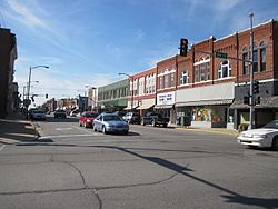
Iowa Falls is a city in Hardin County, Iowa, United States. Iowa Falls is the home of Ellsworth Community College. It is also a regional transportation center, located along U.S. Routes 20 and 65 and the Canadian National and Union Pacific Railroads. The population was 5,106 at the time of the 2020 census.[2]
- ^ "2020 U.S. Gazetteer Files". United States Census Bureau. Retrieved March 16, 2022.
- ^ "2020 Census State Redistricting Data". census.gov. United states Census Bureau. Retrieved August 12, 2021.