Back إروين (بنسيلفانيا) Arabic Irwin (Pennsilvània) Catalan Ирвин (Пенсильвани) CE Irwin (lungsod sa Tinipong Bansa, Pennsylvania) CEB Irwin, Pennsylvania Welsh Irwin (Pensilvania) Spanish Irwin (Pennsylvania) Basque Irwin (Pennsylvanie) French Irwin, Pennsilvani HT Irwin (contea di Westmoreland, Pennsylvania) Italian
Irwin, Pennsylvania | |
|---|---|
Borough | |
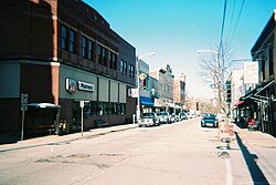
 Irwin's Main Street | |
 Location of Irwin in Westmoreland County, Pennsylvania. | |
| Coordinates: 40°19′40″N 79°42′11″W / 40.32778°N 79.70306°W | |
| Country | United States |
| State | Pennsylvania |
| County | Westmoreland |
| Settled | September 1853 |
| Incorporated | November 14, 1864 |
| Government | |
| • Type | Borough Council |
| • Mayor | Jeff Clem |
| Area | |
| • Total | 0.84 sq mi (2.17 km2) |
| • Land | 0.84 sq mi (2.17 km2) |
| • Water | 0.00 sq mi (0.00 km2) |
| Elevation | 1,007 ft (307 m) |
| Population | |
| • Total | 3,902 |
| • Density | 4,661.89/sq mi (1,800.43/km2) |
| Time zone | UTC-5 (Eastern (EST)) |
| • Summer (DST) | UTC-4 (EDT) |
| Zip code | 15642 |
| Area code | 724 |
| FIPS code | 42-37208 |
| Website | Borough website |
Irwin is a borough in Westmoreland County, Pennsylvania, 22 miles (35 km) southeast of Pittsburgh. Some of the most extensive bituminous coal deposits in the commonwealth are located here. In the past, iron foundries, flour mills, car shops, facing and planing mills, electricals goods, and mirror factories provided employment to the residents. In 1900, the population numbered 2,452; it increased to 2,886 in 1910. The population was 3,973 at the 2010 census.
- ^ "ArcGIS REST Services Directory". United States Census Bureau. Retrieved October 12, 2022.
- ^ "Borough of Irwin". Geographic Names Information System. United States Geological Survey, United States Department of the Interior.
- ^ Cite error: The named reference
USCensusDecennial2020CenPopScriptOnlywas invoked but never defined (see the help page).
