Back Ixtapan de la Sal (municipi) Catalan Ixtapan de la Sal (munisipyo) CEB Municipio Ixtapan de la Sal German Ixtapan de la Sal Esperanto Municipio de Ixtapan de la Sal Spanish Ixtapan de la Sal (udalerria) Basque Ixtapan de la Sal Italian Ixtapan de la Sal (belediye) LAD Ixtapan de la Sal NB Ixtapan de la Sal Polish
Ixtapan de la Sal | |
|---|---|
Town & Municipality | |
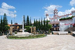
 Main plaza with church | |
 | |
| Coordinates: 18°50′N 99°41′W / 18.833°N 99.683°W | |
| Country | |
| State | State of Mexico |
| Municipal Status | 1822 |
| Government | |
| • Municipal President | Edgar Misael Ocampo Ayala (2022-2024) |
| Elevation (of seat) | 1,880 m (6,170 ft) |
| Population (2010) Municipality | |
| • Municipality | 33,541 |
| • Seat | 15,383 |
| Time zone | UTC-6 (Central) |
| Postal code (of seat) | 51900 |
| Website | www.edomexico.gob.mx/ixtapandelasal (in Spanish) |
Ixtapan de la Sal is a town and municipality located in the State of Mexico, Mexico. It is 60 km south of Toluca, the state's capital, and 120 km south of Mexico City by the Federal Road 55. The word Ixtapan comes from Nahuatl. There are two theories as to the origin of the name. The first one states that it is composed of iztal, which means 'salt', and pan, which means 'over' or 'in'. The second one states that it comes from iztac which means 'white'; atl which means 'water'; and pan which means 'in white waters'. The phrase de la Sal is Spanish for 'of salt'.[1]
There are two rivers in Ixtapan de la Sal. They are the Salado river from the east with a year-round current, and the Salitre river from the northwest with a seasonal current. An aqueduct also passes through the city. Most relevant to tourists is the carbonated water of La Laguna Verde, a spring which filters from the subsoil sprouting naturally in form of water eruptions.[1]
On January 22, 1981, Ixtapan de la Sal officially became a city. In 1996, it was integrated into the 100 Colonial Cities program, a tourist program collecting the oldest and most important Mexican cities in a list.[1]
- ^ a b c "Ixtapan de la Sal". Enciclopedia de los Municipios de Mexico Estado de México.