Back جاسينتو سيتي Arabic جاسينتو سيتى ARZ جاسینتو سیتی، تکزاس AZB Джакинто-Сити (Техас) CE Jacinto City CEB Jacinto City, Texas Welsh Jacinto City Spanish Jacinto City (Texas) Basque جاسینتو سیتی، تگزاس Persian Jacinto City French
City of Jacinto City | |
|---|---|
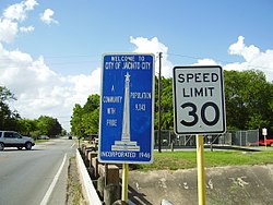
 Jacinto City entrance sign | |
 Location in Harris County and the state of Texas | |
| Coordinates: 29°45′56″N 95°14′25″W / 29.76556°N 95.24028°W | |
| Country | United States |
| State | Texas |
| County | Harris |
| Incorporated | 1947 |
| Area | |
| • Total | 1.85 sq mi (4.80 km2) |
| • Land | 1.85 sq mi (4.80 km2) |
| • Water | 0.00 sq mi (0.00 km2) |
| Elevation | 30 ft (9 m) |
| Population (2020) | |
| • Total | 9,613 |
| • Density | 5,648.14/sq mi (2,180.17/km2) |
| Time zone | UTC-6 (CST) |
| • Summer (DST) | UTC-5 (CDT) |
| ZIP code | 77029 |
| Area code | 713 |
| FIPS code | 48-37156[3] |
| GNIS feature ID | 1374254[2] |
| Website | www |
Jacinto City is a city in Harris County, Texas, United States, east of the intersection of Interstate 10 and the East Loop of Interstate 610. Jacinto City is part of the Houston–Sugar Land–Baytown metropolitan area and is bordered by the cities of Houston and Galena Park. The population was 9,613 at the 2020 census.[4]
- ^ "2019 U.S. Gazetteer Files". United States Census Bureau. Retrieved August 7, 2020.
- ^ a b U.S. Geological Survey Geographic Names Information System: Jacinto City, Texas
- ^ "U.S. Census website". United States Census Bureau. Retrieved January 31, 2008.
- ^ "Profile of General Population and Housing Characteristics: 2010 Demographic Profile Data (DP-1): Jacinto City city, Texas". United States Census Bureau. Retrieved June 15, 2012.