Back مقاطعة جاكسون (ألاباما) Arabic Cekson qraflığı (Alabama) Azerbaijani جکسون بؤلگهسی، آلاباما AZB Jackson County, Alabama BAR Джаксън (окръг, Алабама) Bulgarian জ্যকশন কাউন্টি, আলাবামা BPY Jackson Gông (Alabama) CDO Джексон (гуо, Алабама) CE Jackson County (kondado sa Tinipong Bansa, Alabama) CEB Jackson County, Alabama Welsh
Jackson County | |
|---|---|
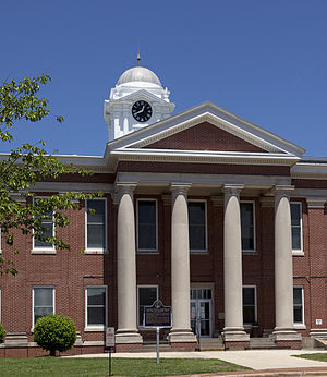
 Jackson County Courthouse in Scottsboro | |
 Location within the U.S. state of Alabama | |
 Alabama's location within the U.S. | |
| Coordinates: 34°47′00″N 86°00′00″W / 34.783333333333°N 86°W | |
| Country | |
| State | |
| Founded | December 13, 1819 |
| Named for | Andrew Jackson |
| Seat | Scottsboro |
| Largest city | Scottsboro |
| Area | |
| • Total | 1,127 sq mi (2,920 km2) |
| • Land | 1,078 sq mi (2,790 km2) |
| • Water | 49 sq mi (130 km2) 4.3% |
| Population (2020) | |
| • Total | 52,579 |
| • Estimate (2023) | 53,467 |
| • Density | 47/sq mi (18/km2) |
| Time zone | UTC−6 (Central) |
| • Summer (DST) | UTC−5 (CDT) |
| Congressional district | 5th |
| Website | www |
| |
Jackson County is the northeasternmost county in the U.S. state of Alabama. As of the 2020 census, the population was 52,579.[1] The county seat is Scottsboro.[2] The county was named for Andrew Jackson, general in the United States Army and afterward President of the United States of America.[3] Jackson County is a prohibition or dry county, but three cities within the county (Bridgeport, Scottsboro, and Stevenson) are "wet", allowing alcohol sales. Jackson County comprises the Scottsboro, AL Micropolitan Statistical Area, and Jackson county is included in the Chattanooga–Cleveland–Dalton combined statistical area. It is the site of Russell Cave National Monument, an archeological site with evidence of 8,000 years of human occupation in the Southeast.
- ^ "State & County QuickFacts". United States Census Bureau. Retrieved September 13, 2023.
- ^ "Find a County". National Association of Counties. Archived from the original on May 31, 2011. Retrieved June 7, 2011.
- ^ Gannett, Henry (1905). The Origin of Certain Place Names in the United States. Govt. Print. Off. pp. 167.
