Back مقاطعة جاكسون (إلينوي) Arabic Jackson County, Illinois BAR Джаксън (окръг, Илинойс) Bulgarian জ্যাকশন কাউন্টি, ইলিনয়স BPY Jackson Gông (Illinois) CDO Джексон (гуо, Иллинойс) CE Jackson County (kondado sa Tinipong Bansa, Illinois) CEB Jackson County, Illinois Welsh Jackson County (Illinois) German Κομητεία Τζάκσον (Ιλινόι) Greek
Jackson County | |
|---|---|
 Jackson County Courthouse in Murphysboro | |
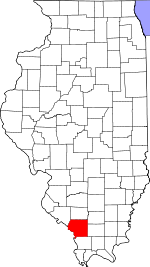
 Location within the U.S. state of Illinois | |
 Illinois's location within the U.S. | |
| Coordinates: 37°47′N 89°23′W / 37.79°N 89.38°W | |
| Country | |
| State | |
| Founded | January 10, 1816 |
| Named for | Andrew Jackson |
| Seat | Murphysboro |
| Largest city | Carbondale |
| Area | |
| • Total | 602 sq mi (1,560 km2) |
| • Land | 584 sq mi (1,510 km2) |
| • Water | 18 sq mi (50 km2) 3.0% |
| Population (2020) | |
| • Total | 52,974 |
| • Estimate (2023) | 52,141 |
| • Density | 88/sq mi (34/km2) |
| Time zone | UTC−6 (Central) |
| • Summer (DST) | UTC−5 (CDT) |
| Congressional district | 12th |
| Website | www |
Jackson County is a county located in the U.S. state of Illinois with a population of 52,974 at the 2020 census, the county is located 98 miles southeast of St. Louis.[1][2] Its county seat is Murphysboro,[3] and its most populous city is Carbondale, home to the main campus of Southern Illinois University. The county was incorporated on January 10, 1816, and named for Andrew Jackson. The community of Brownsville served as the fledgling county's first seat. Jackson County is included in the Carbondale-Marion, IL Metropolitan Statistical Area. It is located in the southern portion of Illinois known locally as "Little Egypt".
- ^ "Distance from Jackson County, IL to Saint Louis, MO". www.travelmath.com. Retrieved June 12, 2024.
- ^ "State & County QuickFacts". US Census Bureau. Archived from the original on June 6, 2011. Retrieved July 6, 2014.
- ^ "Find a County". National Association of Counties. Archived from the original on May 31, 2011. Retrieved June 7, 2011.