Back Jalajala BCL Jalajala CBK-ZAM Jalajala, Rizal CEB Jalajala German Jalajala Spanish Jalajala French Jalajala ID Jalajala ILO Jalajala Italian ხალახალა Georgian
This article needs additional citations for verification. (October 2013) |
Jalajala | |
|---|---|
| Municipality of Jalajala | |
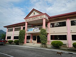
 Jalajala Municipal Hall | |
| Anthem: Himno ng Bayan ng Jalajala | |
 Map of Rizal with Jalajala highlighted | |
Location within the Philippines | |
| Coordinates: 14°21′14″N 121°19′26″E / 14.354°N 121.324°E | |
| Country | Philippines |
| Region | Calabarzon |
| Province | Rizal |
| District | 2nd district |
| Founded | 1823 |
| Annexation to Pililla | October 12, 1903[1] |
| Chartered | March 27, 1907 |
| Barangays | 11 (see Barangays) |
| Government | |
| • Type | Sangguniang Bayan |
| • Mayor | Elmer C. Pillas |
| • Vice Mayor | Jarry V. Añago |
| • Representative | Emigdio P. Tanjuatco III |
| • Municipal Council | Members |
| • Electorate | 22,212 voters (2022) |
| Area | |
| • Total | 44.12 km2 (17.03 sq mi) |
| Elevation | 75 m (246 ft) |
| Highest elevation | 726 m (2,382 ft) |
| Lowest elevation | 2 m (7 ft) |
| Population (2020 census)[4] | |
| • Total | 34,017 |
| • Density | 770/km2 (2,000/sq mi) |
| • Households | 8,143 |
| Economy | |
| • Income class | 4th municipal income class |
| • Poverty incidence | 6.28 |
| • Revenue | ₱ 129.6 million (2020) |
| • Assets | ₱ 364.8 million (2020) |
| • Expenditure | ₱ 129.3 million (2020) |
| • Liabilities | ₱ 155.7 million (2020) |
| Service provider | |
| • Electricity | Manila Electric Company (Meralco) |
| • Water | Manila Water |
| Time zone | UTC+8 (PST) |
| ZIP code | 1990 |
| PSGC | |
| IDD : area code | +63 (0)2 |
| Native languages | Tagalog |
| Website | www |
Jalajala (Tagalog pronunciation: [hälɐ̞ˈhalɐ (-ˈhala)]; also spelled as Jala-jala), officially the Municipality of Jalajala (Tagalog: Bayan ng Jalajala), is a 4th class municipality in the province of Rizal, Philippines. According to the 2020 census, it has a population of 34,017 people, making it the least populated municipality in the province.[4]
- ^ Act No. 942 (October 12, 1903), An Act Reducing the Thirty-Two Municipalities of the Province of Rizal to Fifteen, retrieved June 19, 2022
- ^ Municipality of Jalajala | (DILG)
- ^ "2015 Census of Population, Report No. 3 – Population, Land Area, and Population Density" (PDF). Philippine Statistics Authority. Quezon City, Philippines. August 2016. ISSN 0117-1453. Archived (PDF) from the original on May 25, 2021. Retrieved July 16, 2021.
- ^ a b Census of Population (2020). "Region IV-A (Calabarzon)". Total Population by Province, City, Municipality and Barangay. Philippine Statistics Authority. Retrieved 8 July 2021.
- ^ "PSA Releases the 2021 City and Municipal Level Poverty Estimates". Philippine Statistics Authority. 2 April 2024. Retrieved 28 April 2024.


