Back Jason-1 Czech Jason-1 Finnish Jason 1 Galician Jason-1 ID Jason 1 Italian ジェイソン1 Japanese Jason-1 Latvian/Lettish Jason-1 Polish Jason 1 Portuguese Jason-1 Swedish
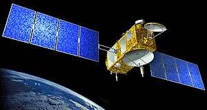
 Artist's interpretation of the Jason-1 satellite | |
| Mission type | Oceanography mission |
|---|---|
| Operator | NASA / CNES |
| COSPAR ID | 2001-055A |
| SATCAT no. | 26997 |
| Website | Ocean Surface Topography from Space |
| Mission duration | 3 years (planned) 11+1⁄2 years (achieved) |
| Spacecraft properties | |
| Bus | Proteus |
| Manufacturer | Thales Alenia Space |
| Launch mass | 500 kg (1,100 lb) |
| Power | 1000 watts |
| Start of mission | |
| Launch date | 7 December 2001, 15:07:00 UTC |
| Rocket | Delta II |
| Launch site | Vandenberg, SLC-2W |
| Contractor | Boeing Defense, Space & Security |
| End of mission | |
| Deactivated | 1 July 2013 |
| Orbital parameters | |
| Reference system | Geocentric orbit |
| Regime | Low Earth orbit |
| Altitude | 1,336 km (830 mi) |
| Inclination | 66.0° |
| Period | 112.56 minutes |
Jason-1 [1] was a satellite altimeter oceanography mission. It sought to monitor global ocean circulation, study the ties between the ocean and the atmosphere, improve global climate forecasts and predictions, and monitor events such as El Niño and ocean eddies.[2] Jason-1 was launched in 2001 and it was followed by OSTM/Jason-2 in 2008, and Jason-3 in 2016 – the Jason satellite series. Jason-1 was launched alongside the TIMED spacecraft.
- ^ "Ocean Surface Topography from Space". NASA/JPL. Archived from the original on 13 May 2008.
 This article incorporates text from this source, which is in the public domain.
- ^ "Jason Sets Sail; Satellite to Spot Sea's Solar/Atmospheric Seesaw". NASA/JPL. Archived from the original on 17 February 2013. Retrieved 30 June 2008.
 This article incorporates text from this source, which is in the public domain.