Back جواكين Arabic جواكين ARZ جواکوین، تکزاس AZB Хоакин (Техас) CE Joaquin (lungsod) CEB Joaquin, Texas Welsh Joaquin (Texas) German Joaquín (Texas) Spanish Joaquin (Texas) Basque جواکوین (تگزاس) Persian
Joaquin, Texas | |
|---|---|
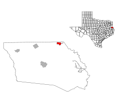
 Location of Joaquin, Texas | |
 | |
| Coordinates: 31°57′57″N 94°03′02″W / 31.96583°N 94.05056°W | |
| Country | United States |
| State | Texas |
| County | Shelby |
| Area | |
| • Total | 2.34 sq mi (6.07 km2) |
| • Land | 2.34 sq mi (6.05 km2) |
| • Water | 0.01 sq mi (0.01 km2) |
| Elevation | 213 ft (65 m) |
| Population (2020) | |
| • Total | 734 |
| • Density | 344.46/sq mi (133.00/km2) |
| Time zone | UTC-6 (Central (CST)) |
| • Summer (DST) | UTC-5 (CDT) |
| ZIP code | 75954 |
| Area code | 936 |
| FIPS code | 48-37684[3] |
| GNIS feature ID | 2410143[2] |
Joaquin (/hwɑːˈkiːn/ whah-KEEN; Spanish: Joaquín [xoaˈkin]) is a city in northeastern Shelby County, Texas, United States. Founded in 1885, it was named after Joaquin Morris, grandson of the original land owner, Benjamin Franklin Morris. Its population was 734 at the 2020 census. It is located on U.S. Highway 84 (future Interstate 69) and the tracks of the Southern Pacific Railroad.
- ^ "2019 U.S. Gazetteer Files". United States Census Bureau. Retrieved August 7, 2020.
- ^ a b U.S. Geological Survey Geographic Names Information System: Joaquin, Texas
- ^ "U.S. Census website". United States Census Bureau. Retrieved January 31, 2008.