Back Jurong Island Danish Isla Jurong Spanish Jurongsaari Finnish Jurong (île) French Pulau Jurong ID ジュロン島 Japanese Pulau Jurong Malay Jurong (eiland) Dutch Jurong Island Polish Ilha de Jurong Portuguese
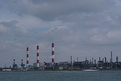
 Jurong Island, photographed in February 2011 | |
| Geography | |
|---|---|
| Location | Southeast Asia |
| Coordinates | 1°16′12″N 103°41′45″E / 1.2701°N 103.6959°E |
| Archipelago | Malay Archipelago |
| Area | 32 km2 (12 sq mi) |
| Administration | |
| Region | West Region |
| Planning Area | Western Islands
|
| CDC | |
| Town council |
|
| Constituency | |
| Member of Parliament | |
Jurong Island is an island located to the southwest of the main island of Singapore. It was formed from the amalgamation of seven offshore islands, the islands of Pulau Ayer Chawan, Pulau Ayer Merbau, Pulau Merlimau, Pulau Pesek, Pulau Pesek Kechil (also called Terumbu Pesek), Pulau Sakra (which was a previous merger of Pulau Sakra and Pulau Bakau), Pulau Seraya, Pulau Meskol, Pulau Mesemut Laut, Pulau Mesemut Darat and Anak Pulau. This was done through Singapore's land reclamation efforts. Land reclamation on Jurong Island was completed on 25 September 2009, 20 years earlier than scheduled. Pulau Buaya was joined to Jurong Island via reclamation in 2010. Jurong Island forms a land area of about 32 km2 (12 sq mi) from an initial area of less than 10 km2 (4 sq mi), and is the largest of Singapore's outlying islands.

