Back Kaiwaka CEB Kaiwaka (Neuseeland) German Kaiwaka French Kaiwaka Maori Kaiwaka Malay Kaiwaka NN Kaiwaka Polish Kaiwaka SIMPLE
Kaiwaka | |
|---|---|
 Jaques Four Square supermarket | |
| Nickname: The little town of lights[1] | |
 | |
| Coordinates: 36°9′40″S 174°26′37″E / 36.16111°S 174.44361°E | |
| Country | New Zealand |
| Region | Northland Region |
| District | Kaipara District |
| Ward | Kaiwaka-Mangawhai Ward |
| Electorates | |
| Government | |
| • Territorial Authority | Kaipara District Council |
| • Regional council | Northland Regional Council |
| Area | |
| • Total | 7.57 km2 (2.92 sq mi) |
| Population (June 2024)[3] | |
| • Total | 920 |
| • Density | 120/km2 (310/sq mi) |

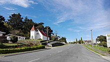
Kaiwaka, known as "the little town of lights",[1] is a settlement in Northland, New Zealand. The Kaiwaka River runs from the east through the area and joins with the Wairau River to form the Otamatea River, which drains into the Kaipara Harbour. State Highway 1 passes through Kaiwaka. Wellsford is 20 kilometres (12 mi) south, Brynderwyn is 8 kilometres (5.0 mi) north, and Whangārei, the closest city, is 60 kilometres (37 mi) (a 45-minute drive) to the north. The Mangawhai Heads are 18 kilometres (11 mi) northeast of Kaiwaka.[4][5]
The New Zealand Ministry for Culture and Heritage gives a translation of eating the canoes for Kaiwaka.[6] The reference to food and canoe may reflect the historic Mangapai portage route between Kaiwaka and Mangawhai linking the east coast with the Kaipara Harbour.[7]
Local tradition also speaks of a cloud that is only observed in this part of the Kaipara. It is seen as an omen that a high ranking person is about to pass on.[8] He kapua pōuri ngā kaiwaka kei runga i te paerangi. He tohu aituā tēnei (Te Ara 2015). / Kaiwaka are threatening clouds on the horizon. This a sign of misfortune.[9]
- ^ a b "2009 : 150 years of Kaiwaka, the little town of lights (record)". National Library of New Zealand. 2009.
- ^ Cite error: The named reference
Areawas invoked but never defined (see the help page). - ^ "Aotearoa Data Explorer". Statistics New Zealand. Retrieved 26 October 2024.
- ^ Peter Dowling, ed. (2004). Reed New Zealand Atlas. Reed Books. pp. map 8. ISBN 0-7900-0952-8.
- ^ Roger Smith, GeographX (2005). The Geographic Atlas of New Zealand. Robbie Burton. pp. map 31. ISBN 1-877333-20-4.
- ^ "1000 Māori place names". New Zealand Ministry for Culture and Heritage. 6 August 2019.
- ^ Hooker, Brian (September 1997). "Portages of early Auckland - to and from the Waitemata Harbour: The hub of an ancient communications network". folksong.org.nz. Retrieved 31 January 2021.
- ^ A.W. Read, Revised by Peter Dowling (2010). Place Names of New Zealand. Penguin Group. p. 193. ISBN 9780143204107.
- ^ "Kaiwaka". maoridictionary.co.nz. 2021. Retrieved 31 January 2021.