Back Kamareddy (Distrikt) German بخش کاماریدی Persian कामारेड्डी ज़िला Hindi कामारेड्डी जिल्हा Marathi कामारेड्डी जिल्ला Nepali ᱠᱟᱢᱟᱨᱮᱰᱰᱤ ᱦᱚᱱᱚᱛ SAT காமாரெட்டி மாவட்டம் Tamil కామారెడ్డి జిల్లా Tegulu کاماریڈی ضلع Urdu
Kamareddy district | |
|---|---|
 Temple at Domakonda fort | |
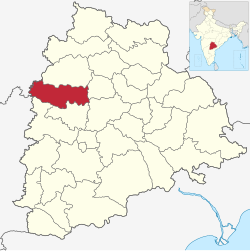
 Location in Telangana | |
| Country | |
| State | Telangana |
| Headquarters | Kamareddy |
| Mandalas | 23 |
| Government | |
| • District Collector | Shri Jithesh V Patil IAS |
| • Parliament constituencies | 1 |
| Area | |
| • Total | 3,652 km2 (1,410 sq mi) |
| Population (2015) | |
| • Total | 1,004,259 |
| • Density | 277.2/km2 (718/sq mi) |
| Demographics | |
| • Literacy | 56.51 |
| • Sex ratio | 1033 |
| Time zone | UTC+05:30 (IST) |
| Vehicle registration | TG–17[1] |
| Website | kamareddy |
Kamareddy district is a district located in the western region of the Indian state of Telangana.[2][3] The district shares boundaries with Medak, Nizamabad, Sangareddy, Siddipet and Rajanna Sircilla districts and with the state boundary of Maharashtra and Karnataka.
- ^ "Telangana New Districts Names 2016 Pdf TS 31 Districts List". Timesalert.com. 11 October 2016. Retrieved 11 October 2016.
- ^ "Kamareddy district" (PDF). Chief Commissioner of Land Administration. Archived from the original (PDF) on 9 September 2016. Retrieved 22 August 2016.
- ^ "New districts map". newdistrictsformation.telangana.gov.in. Retrieved 22 August 2016.[permanent dead link]
