Back نهر كامو Arabic نهر كامو ARZ Kamo-gawa (suba sa Hapon, lat 34,96, long 135,76) CEB Kamo (Fluss) German Río Kamo (Kioto) Spanish Kamo jõgi Estonian رود کامو Persian Kamojoki Finnish Kamo-gawa French Sungai Kamo ID
| Kamo River | |
|---|---|
 Cherry blossoms along the Kamo River | |
 | |
| Native name | 鴨川 (Japanese) |
| Location | |
| Country | Japan |
| Physical characteristics | |
| Mouth | |
• location | Yodo River |
| Length | 31 km (19 mi) |
| Basin size | 210 km2 (81 sq mi) |
| Basin features | |
| River system | Yodo River |


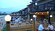
The Kamo River (鴨川, Kamo-gawa, duck river – see onomastics) is located in Kyoto Prefecture, Japan. The riverbanks are popular walking spots for residents and tourists. In summer, restaurants open balconies looking out to the river. There are walkways running alongside the river, and some stepping stones that cross the river. The water level of the river is usually relatively low; less than one meter in most places. During the rainy season, however, the walkways sometimes flood in their lower stretches.
It is known for the two Kamo Shrines on its course: Kamigamo Shrine and Shimogamo Shrine and the shared Chinju no Mori between them Tadasu-no-mori.