Back Kama Tamaqı rayonu Azerbaijani Камска-Ўсьцінскі раён BE-X-OLD Камски Устьен кӀошт CE Kamsko-Ust'inskiy Rayon CEB Kamskoje Ustje rajoon Estonian شهرستان کامسکو-اوستینسکی Persian Kamszkoje Usztyje-i járás Hungarian Կամսկոյե Ուստյեի շրջան Armenian Kamsko-Ust'inskij rajon Italian Камское Устье кундем MHR
Kamsko-Ustyinsky District
Камско-Устьинский район | |
|---|---|
| Other transcription(s) | |
| • Tatar | Кама Тамагы районы |
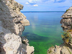
 A cave system, a protected area of Russia, in Kamsko-Ustyinsky District | |
 Location of Kamsko-Ustyinsky District in the Republic of Tatarstan | |
| Coordinates: 55°16′N 49°02′E / 55.267°N 49.033°E | |
| Country | Russia |
| Federal subject | Republic of Tatarstan |
| Established | 12 January 1965 |
| Administrative center | Kamskoye Ustye |
| Area | |
| • Total | 1,199 km2 (463 sq mi) |
| Population | |
| • Total | 16,904 |
| • Density | 14/km2 (37/sq mi) |
| • Urban | 47.1% |
| • Rural | 52.86% |
| Administrative structure | |
| • Inhabited localities | 3 Urban-type settlements[2], 49 rural localities |
| Municipal structure | |
| • Municipally incorporated as | Kamsko-Ustyinsky Municipal District |
| • Municipal divisions | 3 urban settlements, 17 rural settlements |
| Time zone | UTC+3 (MSK |
| OKTMO ID | 92630000 |
| Website | http://kamskoye-ustye.tatarstan.ru |
Kamsko-Ustyinsky District (Russian: Камско-Устьинский райо́н; Tatar: Кама Тамагы районы) is a territorial administrative unit and municipality of the Republic of Tatarstan within the Russian Federation. The district is located in the west of the republic, on the right bank of the Volga River. The territory of the district includes 49 settlements which are organized into three urban and seventeen rural settlements. The district population was 14,747 in 2020. The administrative center of the district is the urban-type settlement Kamskoye Ustye.[4][5]
- ^ Russian Federal State Statistics Service (2011). Всероссийская перепись населения 2010 года. Том 1 [2010 All-Russian Population Census, vol. 1]. Всероссийская перепись населения 2010 года [2010 All-Russia Population Census] (in Russian). Federal State Statistics Service.
- ^ The count of urban-type settlements may include the work settlements, the resort settlements, the suburban (dacha) settlements, as well as urban-type settlements proper.
- ^ "Об исчислении времени". Официальный интернет-портал правовой информации (in Russian). June 3, 2011. Retrieved January 19, 2019.
- ^ "Численность населения муниципальных образований Республики Татарстан на начало 2020 года. Статистический бюллетень" [Population of the municipalities of the Republic of Tatarstan at the beginning of 2020. Statistical Bulletin] (PDF). Территориальный орган Федеральной службы госстатистики по Республике Татарстан [Territorial'nyj organ Federal'noj sluzhby GosStatistiki]. 2020. Retrieved December 25, 2020.
- ^ "Камско-Устьинский район. Справка" [Kamsko-Ust'insky region. reference]. Tatarica. 2020. Retrieved December 25, 2020.

