Back Kamwenge District CEB Distrikt Kamwenge German Distrito de Kamwenge Spanish Kamwenge (district) French Distrik Kamwenge ID Distretto di Kamwenge Italian カムウェンゲ県 Japanese 캄웽게구 Korean Kamwenge (disitulikit) LG Kamwenge (district) Dutch
Kamwenge District | |
|---|---|
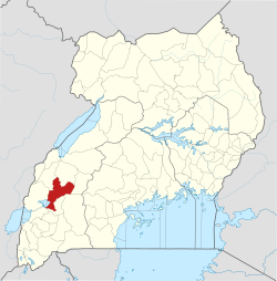
 District location in Uganda | |
| Coordinates: 00°14′11″N 30°29′30″E / 0.23639°N 30.49167°E | |
| Country | |
| Region | Western Uganda |
| Sub-region | Toro sub-region |
| Capital | Kamwenge |
| Area | |
| • Total | 2,439.4 km2 (941.9 sq mi) |
| • Land | 2,375.3 km2 (917.1 sq mi) |
| • Water | 64.1 km2 (24.7 sq mi) |
| Population (2014 Census) | |
| • Total | 249,100 |
| • Density | 139.8/km2 (362/sq mi) |
| Time zone | UTC+3 (EAT) |
| Website | www |


Kamwenge District is a district in Western Uganda. It is named after its 'chief town', Kamwenge, where the district headquarters are located. Kamwenge District is part of the Kingdom of Toro, one of the ancient traditional monarchies in Uganda. The kingdom is coterminous with Toro sub-region. The districts that constitute the sub-region are: (a) Bunyangabu District (b) Kabarole District (c) Kamwenge District (d) Kyegegwa District (e) Kitagwenda District and (f) Kyenjojo District.[1]

- ^ Uganda Farmers Guide (2019). "View Farmers Groups in Toro Sub Region". Kampala: Uganda Farmers Guide. Retrieved 28 November 2019.