Back كانجرا Arabic كانجرا ARZ कांगड़ा जिला Bihari কাংড়া জেলা Bengali/Bangla Districte de Kangra Catalan Kāngra (distrito) CEB Kangra (distrikt) Danish Kangra (Distrikt) German Distrito de Kangra Spanish Kangra barrutia Basque
Kangra district
Nagarkot, Trigarta | |
|---|---|
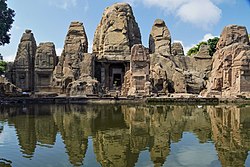
Clockwise from top-left: Baijnath Shiva temple, McLeod Ganj from Dalai Lama temple, Ranjit Singh Gate, Kangra Fort, Masrur Temples, View of Dhauladhar Range from Triund | |
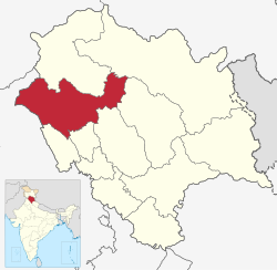
 Location in Himachal Pradesh | |
| Coordinates: 32°13′0″N 76°19′0″E / 32.21667°N 76.31667°E | |
| Country | |
| State | |
| Division, Part of | Kangra |
| Tehsils | |
| Headquarters | Dharamshala |
| Government | |
| • Lok Sabha Constituency, part of | |
| • Member of Parliament, Lok Sabha | Rajeev Bhardwaj[1] |
| • Deputy Commissioner | Nipun jindal, IAS[2] |
| • Superintendent of Police | Vimukt Ranjan, IPS[3] |
| Area | |
| • Total | 5,739 km2 (2,216 sq mi) |
| Highest elevation | 5,930 m (19,460 ft) |
| Lowest elevation | 500 m (1,600 ft) |
| Population (2011) | |
| • Total | 1,510,075 |
| • Density | 263/km2 (680/sq mi) |
| Time zone | UTC+5:30 (IST) |
| Vehicle registration | HP- 68(RTO), 01/ 02D(Taxi) |
| Largest city | Dharamshala |
| Gender ratio | 1012 females/1000 males |
| Literacy rate | 85.67% |
| Vidhan Sabha Constituencies | 15
|
| Climate | ETh (Köppen) |
| Avg. summer temperature | 32 °C (90 °F) |
| Avg. winter temperature | 20 °C (68 °F) |
| Website | hpkangra |
Kangra district is the most populous[5] district of the Indian state of Himachal Pradesh. Dharamshala is the administrative headquarters of the district.
- ^ "Members : Lok Sabha".
- ^ "Deputy Commissioner Kangra, Himachal Pradesh | District Kangra, Government of Himachal Pradesh | India".
- ^ "Who's Who | District Kangra, Government of Himachal Pradesh | India".
- ^ "Hanuman Tibba Climbing Expedition (19450 Ft.)".
- ^ "District Census 2011". Census2011.co.in. 2011. Retrieved 30 September 2011.


