Back Propinsi Karagandy ACE أوبليس كارقندا Arabic काराग़ान्दी प्रांत AWA Karağandı vilayəti Azerbaijani قراغندی اوستانی AZB Карагандзінская вобласць Byelorussian Карагандзінская вобласьць BE-X-OLD Карагандинска област Bulgarian Província de Kharagandí Catalan Карагандин область CE
Karaganda Region
Қарағанды облысы (Kazakh) | |
|---|---|
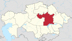
 Map of Kazakhstan, location of Karaganda Region highlighted | |
| Coordinates: 48°0′N 71°0′E / 48.000°N 71.000°E | |
| Country | |
| Capital | Karaganda |
| Government | |
| • Akim | Ermaganbet Bulekpaev[1] |
| Area | |
| • Total | 427,982 km2 (165,245 sq mi) |
| Highest elevation | 1,565 m (5,135 ft) |
| Lowest elevation | 500 m (1,600 ft) |
| Population (2018)[4] | |
| • Total | 1,378,863 |
| • Density | 3.2/km2 (8.3/sq mi) |
| GDP | |
| • Total | KZT 7,278.1 billion US$ 15.763 billion (2022) |
| • Per capita | KZT 6,412,900 US$ 13,889 (2022) |
| Time zone | UTC+05:00 |
| • Summer (DST) | UTC+05:00 (unchanged) |
| Postal codes | 100000 |
| Area codes | +7 (721) |
| ISO 3166 code | KZ-KAR |
| Vehicle registration | 09, M |
| Districts | 9 |
| Cities | 11 |
| Townships | 39 |
| Villages | 557 [6] |
| HDI (2022) | 0.823[7] very high · 2nd |
| Website | karaganda-region |
Karaganda Region (Kazakh: Қарағанды облысы, romanized: Qarağandy oblysy; Russian: Карагандинская область) is a region of Kazakhstan. Its capital is Karaganda. The region borders Akmola and Pavlodar Region to the north, Abai Region to the east, Jetisu, Almaty, and Zhambyl Regions to the south, and Kostanay and Ulytau regions to the west.
In 2022, the western parts of this region was split off and became the Ulytau Region.
- ^ "О назначении Булекпаева Е.К." (in Russian). akorda.kz. 8 December 2022. Retrieved 8 December 2022.
- ^ "Official site - General Information". Archived from the original on 6 July 2017. Retrieved 17 November 2017.
- ^ https://maps.vlasenko.net/smtm1000/m-43.jpg
- ^ Agency of statistics of the Republic of Kazakhstan: Численность населения Республики Казахстан по областям с начала 2013 года до 1 февраля 2013 года (russisch; Excel-Datei; 55 kB).
- ^ DOSM. "Department of Statistics Kazakhstan". stat.gov.kz. Archived from the original on 2 January 2024. Retrieved 1 March 2023.
- ^ All-Biz Ltd. Карагандинская область
- ^ "Sub-national HDI – Area Database – Global Data Lab". hdi.globaldatalab.org.


