Back كرنال Arabic كرنال ARZ करनाल AWA करनाल जिला Bihari Districte de Karnal Catalan Karnāl (distrito) CEB Karnal (Distrikt) German Distrito de Karnal Spanish Karnal barrutia Basque بخش کارنال Persian
This article needs to be updated. (January 2022) |
Karnal district | |
|---|---|
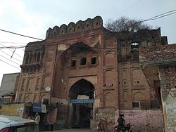
 Fort of Prithviraj Chauhan in Taraori | |
 Location in Haryana | |
| Country | India |
| State | Haryana |
| Division | Karnal |
| Headquarters | Karnal |
| Tehsils | 1. Gharaunda, 2. Nilokheri, 3. Indri, 4. Karnal, 5. Assandh |
| Area | |
| • Total | 2,520 km2 (970 sq mi) |
| Population (2011) | |
| • Total | 1,505,324 |
| • Density | 600/km2 (1,500/sq mi) |
| • Urban | 26.51% |
| Demographics | |
| • Literacy | 74.73% |
| • Sex ratio | 887 |
| Time zone | UTC+05:30 (IST) |
| Lok Sabha constituencies | Karnal (shared with Panipat district) |
| Vidhan Sabha constituencies | 5 |
| Website | http://www.karnal.gov.in/ |
Karnal district is one of the 22 districts of Haryana, a state in North India which constitutes the National Capital Region (NCR) of the country. The city of Karnal is a part of the National Capital Region (NCR) and is the administrative headquarters of the district.
As it lies on National highway 44 (old NH-1), it has a well connected transport system to the nearby major cities like Delhi and Chandigarh. Karnal District is also well connected via railways. Karnal Junction lies on Delhi-Kalka line and major trains stops at this station. The district headquarter also has a small aerodrome known as karnal airport.