Karori | |
|---|---|
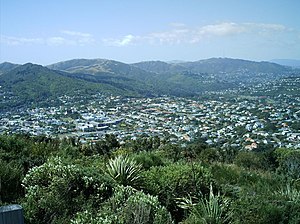
 City-end Karori from Wrights Hill summit | |
 | |
| Coordinates: 41°17′05″S 174°44′12″E / 41.284855°S 174.736795°E | |
| Country | New Zealand |
| City | Wellington City |
| Local authority | Wellington City Council |
| Electoral ward |
|
| Established | 1840 |
| Area | |
| • Land | 628 ha (1,552 acres) |
| Population (June 2024)[2] | |
| • Total | 15,330 |
| Postcode(s) | 6012 |
| Mākara | Wilton | |
|
|
Northland | |
| Highbury, Taitville |
Karori is a suburb located at the western edge of the urban area of Wellington, New Zealand, 4 kilometres (2.5 miles) from the city centre[3] and is one of New Zealand's most populous suburbs,[3] with a population of 15,330 in June 2024.[2] The name Karori used to be Kaharore and is from the Māori language. No Māori lived in the area, when the first European settlers came to Karori in the 1840s. The first settler in Karori cleared 20 acres of forest on his section with his younger brother Moses and advertised its sale in December 1841.
Amenities in Karori include, a community garden, a library, a swimming pool, and several church buildings.
- ^ Cite error: The named reference
Areawas invoked but never defined (see the help page). - ^ a b "Aotearoa Data Explorer". Statistics New Zealand. Retrieved 26 October 2024.
- ^ a b Jago, Francesca (16 December 2014). "Let's live in... Karori". Stuff. Retrieved 15 March 2015.
