Back كنشاي رام نجر Arabic كنشاى رام نجر ARZ कासगंज जिला Bihari কাশগঞ্জ জেলা Bengali/Bangla Kanshiram Nagar CEB Kanshiram Nagar (distrikt) Danish Kasganj (Distrikt) German Distrito de Kanshiram Nagar Spanish Kasganj barrutia Basque بخش کانسیرامنگر Persian
Kasganj district | |
|---|---|
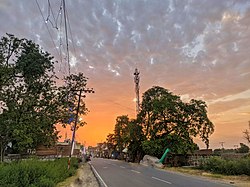
 Sunset in Bilram | |
 | |
| Coordinates: 27°49′N 78°39′E / 27.82°N 78.65°E | |
| Country | |
| State | Uttar Pradesh |
| Division | Aligarh |
| Headquarters | Kasganj |
| Area | |
| • Total | 1,993 km2 (770 sq mi) |
| Population (2011) | |
| • Total | 1,436,719 |
| • Density | 720/km2 (1,900/sq mi) |
| Languages | |
| • Official | Hindi |
| Time zone | UTC+5:30 (IST) |
| ISO 3166 code | IN-UP-KN |
| Literacy | 62.3% |
| Website | https://kasganj.nic.in/ |
Kasganj district (earlier called Kanshiram Nagar) is a district of the Indian state Uttar Pradesh. It is located in the division of Aligarh and consists of Kasganj, Patiali and Sahawar tehsils. Its headquarters is at Kasganj.[1]
- ^ "Kanshiram Nagar to be State's 71st district". Archived from the original on 13 May 2009. Retrieved 20 May 2015.