Back Kew Gardens (Queens) French Kew Gardens, Queens Irish Kew Gardens (Queens) Italian キュー・ガーデン地区 Japanese کیو گارڈنز، کوئینز Urdu
Kew Gardens | |
|---|---|
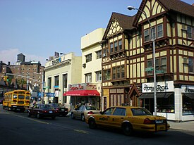
 Businesses on Lefferts Boulevard | |
 Location within New York City | |
| Coordinates: 40°42′18″N 73°49′30″W / 40.705°N 73.825°W | |
| Country | |
| State | |
| City | |
| County/Borough | |
| Community District | Queens 9[1] |
| Named for | Royal Botanic Gardens, Kew[2] |
| Population | |
| • Total | 24,371 |
| Race/Ethnicity | |
| • White | 40.0% |
| • Hispanic | 27.2% |
| • Asian | 18.3% |
| • Black | 7.8% |
| • Other/Multiracial | 6.7% |
| Economics | |
| • Median income | $61,287 [4] |
| Time zone | UTC−5 (EST) |
| • Summer (DST) | UTC−4 (EDT) |
| ZIP Code | 11415 |
| Area codes | 718, 347, 929, and 917 |
| Website | www |
Kew Gardens is a neighborhood in the central area of the New York City borough of Queens. Kew Gardens is bounded to the north by the Union Turnpike and the Jackie Robinson Parkway (formerly the Interboro Parkway), to the east by the Van Wyck Expressway and 131st Street, to the south by Hillside Avenue, and to the west by Park Lane, Abingdon Road, and 118th Street. Forest Park is to the west and the neighborhood of Forest Hills to the north-west, Flushing Meadows–Corona Park north, Richmond Hill south, Briarwood southeast, and Kew Gardens Hills east.
Kew Gardens is located in Queens Community District 9 and its ZIP Code is 11415.[1] It is patrolled by the New York City Police Department's 102nd Precinct.[5] Politically, Kew Gardens is represented by the New York City Council's 29th District.[6]
- ^ a b "NYC Planning | Community Profiles". communityprofiles.planning.nyc.gov. New York City Department of City Planning. Retrieved April 7, 2018.
- ^ "Next to the L.I.R.R. Tracks; Five 2-Family Houses For Kew Gardens", The New York Times, April 24, 1994. Accessed August 27, 2018. "In 1909, when train service began on the Long Island Rail Road, the northerly section of the Man property was renamed Kew Gardens, also after a section of London."
- ^ a b [1] "New York City 2020 Census Results"
- ^ "Kew Gardens neighborhood in Kew Gardens, New York (NY), 11418, 11415, 11435 subdivision profile - real estate, apartments, condos, homes, community, population, jobs, income, streets".
- ^ Cite error: The named reference
NYPD 102nd Precinctwas invoked but never defined (see the help page). - ^ Current City Council Districts for Queens County, New York City. Accessed May 5, 2017.