Back Xocalı rayonu Azerbaijani خوجالی رایونو AZB Xocalı Breton Ходжалин кӀошт CE Xocalı Rayonu CEB Hocalı (rayon) CRH Xocalı (rajón) Czech Xocalı (Rayon) German Ĥoĝala distrikto Esperanto Raión de Jóyali Spanish
Khojaly District | |
|---|---|
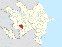
 Map of Azerbaijan showing Khojaly District | |
| Country | |
| Region | Karabakh |
| Established | 26 November 1991 |
| Capital | Khojaly |
| Settlements[1] | 53 |
| Government | |
| • Governor | Shahmar Usubov |
| Area | |
| • Total | 1,000 km2 (400 sq mi) |
| Population | |
| • Total | 28,800 |
| • Density | 29/km2 (75/sq mi) |
| Time zone | UTC+4 (AZT) |
| Postal code | 2600 |
| Website | xocali-ih |
Khojaly District (Azerbaijani: Xocalı rayonu) is one of the 66 districts of Azerbaijan. It is located in the west of the country in the Karabakh Economic Region. The district borders the districts of Kalbajar, Lachin, Shusha, Agdam and Khojavend. Its capital and largest city is Khojaly. As of 2020, the district had a nominal population of 28,800.[2]
The centre of the district, the town of Khojaly, was also the site of the Khojaly Massacre, the largest massacre throughout the whole Nagorno-Karabakh conflict. Following the massacre, most of the district was captured and made part of the Askeran Province of the self-proclaimed Republic of Artsakh. Following the 2020 Nagorno-Karabakh war, Azerbaijan recaptured some villages in the district, while most of the district, including its capital, was put under Russian peacekeeping control. After the 2023 Azerbaijani offensive in Nagorno-Karabakh, the entire district fell under the control of Azerbaijan after the capitulation of the Artsakh Defence Army in the area.[3]
- ^ "İnzibati-ərazi vahidləri" (PDF). preslib.az. Retrieved 28 February 2021.
- ^ a b "Population of Azerbaijan". stat.gov.az. State Statistics Committee. Retrieved 22 February 2021.
- ^ Sauer, Pjotr (28 September 2023). "Nagorno-Karabakh's breakaway government says it will dissolve itself". The Guardian. Retrieved 28 September 2023.