Kingdom of Valluvanad Valluvanad | |
|---|---|
| 1124–1793 | |
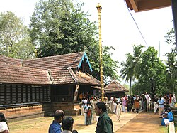
 Thirumandhamkunnu Temple | |
| Capital | Angadipuram, Perinthalmanna taluk, Malappuram district, Kerala, India |
| Common languages | Malayalam. |
| Government | Monarchy |
| History | |
• Established | 1124 |
• Disestablished | 1793 |
Valluvanad was an independent chiefdom in present-day central Kerala that held power from the early 12th century to the end of the 18th century. Prior to that, and since the late 10th century, Valluvanad existed as an autonomous chiefdom within the kingdom of the Chera Perumals.[1][2] The disintegration of the Chera Perumal kingdom in early 12th century led to the independence of the various autonomous chiefdoms of the kingdom, Valluvanad being one of them.
The earliest mention of the term "Valluvanad" as a political entity, from the 9th and early 10th century, are references to a region within the Ay kingdom in the south Kerala, then a vassal to the Pandya kingdom.[3] It is possible that the new chiefdom in central Kerala (within the kingdom of the Chera Perumals) derives its origin from this eponymous subdivision in south Kerala.[1] Valluvanad was ruled by a Samanthan Nair clan known as Vellodis, similar to the Eradis of neighbouring Eranad and Nedungadis of Nedunganad. The rulers of Valluvanad were known by the title Valluvakonathiri/Vellattiri.[4][5]
The geographical bounds of Valluvanad are hard to assess from available sources, and did vary significantly in time. It has been generally described as the region between the knolls of Pandalur Hills (a hill that separates old Eranad Taluk from Valluvanad Taluk, located in Malappuram-Manjeri area) and the seashore of Ponnani.[6] The country covered the Bharathapuzha river basin in the south to the Pandalur Hills in the north. On the west, it was bounded by the Arabian Sea at the port Ponnani and on the east by Attappadi Hills. In the 12th century, Valluvanad had parts of present-day Nilambur (Nilambur-Wandoor-Karuvarakundu-Tuvvur area), Eranad (Pandikkad-Manjeri-Malappuram areas), Tirur (Tirunavaya-Athavanad-Kottakkal-Valanchery areas), and Ponnani Taluks within it, with Ponnani port providing the main access to the sea. At that time a larger part of the basins of Chaliyar and Kadalundi River were ruled by Valluvakonathiri. In its maximal extend, its northern boundary was Thrikkulam at Tirurangadi in Tirurangadi Taluk and southern border was Edathara near Palakkad. A larger portion of what is presently called Eranad region was originally under the Kingdom of Valluvanad before the conquest of Zamorin of Calicut. In early medieval period, Valluvakonathiri conquered a larger portion of Nedunganad (Pattambi-Ottapalam-Shoranur-Cherpulassery area), which was under the rule of Nedungathirippad. However Nedunganad was annexed by the Zamorin of Calicut in 15th century CE. The Nedumpuram Palace near Thiruvalla belongs to Valluvanad Royal family.
The chiefdom was disestablished in 1793 with the British East India Company taking over its management directly, and the hereditary ruling family settling for a pension arrangement.
- ^ a b Narayanan, M.G.S. (2013). Perumāḷs of Kerala : Brahmin oligarchy and ritual monarchy : political and social conditions of Kerala under the Cēra Perumāḷs of Makōtai (c. AD 800-AD 1124). Thrissur: CosmoBooks. ISBN 9788188765072.
- ^ Ganesh, K. N. (2009). Historical Geography of Natu in South India with Special Reference to Kerala. Indian Historical Review, 36(1), 3–21.
- ^ Rao, Gopinatha (1910). Travancore Archaeological Series (PDF). Madras Methodist Publishing House. p. 5.
- ^ Kerala (India); Menon, A. Sreedhara (1986). Kerala District Gazetteers. Superintendent of Government Presses,University of Michigan. p. 224.
- ^ Schneider, David Murray; Gough, Kathleen (1961). Matrilineal Kinship. University of California Press. p. 307. ISBN 978-0-520-02529-5.
- ^ S. Rajendu - History of Valluvanad - from pre-historic times to A.D. 1792, Malayalam, Perintalmanna, 2012
