Back Kitgum District CEB Distrikt Kitgum German Distrito de Kitgum Spanish ناحیه کیتگوم Persian Kitgum (district) French Distrik Kitgum ID Distretto di Kitgum Italian キトゥグム県 Japanese 키트굼구 Korean Kitgum (disitulikit) LG
Kitgum District | |
|---|---|
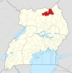
 District location in Uganda | |
| Coordinates: 03°13′N 32°47′E / 3.217°N 32.783°E | |
| Country | |
| Region | Northern Uganda |
| Sub-region | Acholi sub-region |
| Capital | Kitgum |
| Area | |
| • Total | 3,960 km2 (1,530 sq mi) |
| Population (2012 Estimate) | |
| • Total | 247,800 |
| • Density | 62.6/km2 (162/sq mi) |
| Time zone | UTC+3 (EAT) |
| Website | www |


Kitgum District is a district in Northern Uganda. It is named after its major town of Kitgum, where the district headquarters is located. It has suffered much fatalities and social disruption resulting from the 20-year civil war in the region during the late 20th century. The government moved tens of thousands of residents to internally displaced persons camps for their protection, where they were subject to raids by the rebels and also harsh conditions, including disease.