Back Клойсберген Bulgarian Kluisbergen Breton Kluisbergen Catalan Kluisbergen CEB Kluisbergen German Kluisbergen Esperanto Kluisbergen Spanish Kluisbergen Estonian Kluisbergen Basque کلوئیزبرژان Persian
Kluisbergen | |
|---|---|
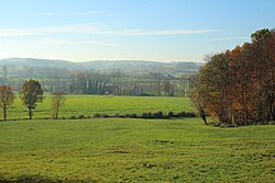
 Typical Flemish Ardennes landscape | |
| Coordinates: 50°47′N 03°31′E / 50.783°N 3.517°E | |
| Country | |
| Community | Flemish Community |
| Region | Flemish Region |
| Province | East Flanders |
| Arrondissement | Oudenaarde |
| Government | |
| • Mayor | Philippe Willequet |
| • Governing party/ies | Gemeentebelangen |
| Area | |
| • Total | 30.63 km2 (11.83 sq mi) |
| Population (2018-01-01)[1] | |
| • Total | 6,453 |
| • Density | 210/km2 (550/sq mi) |
| Postal codes | 9690 |
| NIS code | 45060 |
| Area codes | 055 |
| Website | www.kluisbergen.be |
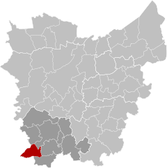
Kluisbergen (Dutch pronunciation: [ˈklœyzˌbɛrɣə(n)]) is a municipality located in the Belgian province of East Flanders, along the Scheldt river. The municipality comprises the towns of Berchem, Kwaremont, Ruien and Zulzeke which fused in 1971. In 2021, Kluisbergen had a total population of 6,682. The total area is 30.38 km².[2] The town of Ruien is the largest and has some outdoor facilities. Kluisbergen is also home to the "Kluisbos", a forest which has 2 ancient standing stones, dating back to Roman times.
- ^ "Wettelijke Bevolking per gemeente op 1 januari 2018". Statbel. Retrieved 9 March 2019.
- ^ "Bevolking per statistische sector - Sector 45060". Statistics Belgium. Retrieved 9 May 2022.


