Back Клымэць Byelorussian Климец CE Klymez German Klimec Hungarian Klimiec Polish Klîmeț, Skole Romanian Климец Russian Климець Ukrainian 克利梅齊 Chinese Klymets ZH-MIN-NAN
Klymets
Климець Klimiets | |
|---|---|
 | |
| Coordinates: 48°50′19″N 23°10′41″E / 48.83861°N 23.17806°E | |
| Country | |
| Province | |
| District | Stryi Raion |
| Established | 1565 |
| Area | |
| • Total | 128 km2 (49 sq mi) |
| Elevation /(average value of) | 777 m (2,549 ft) |
| Population | |
| • Total | 342 |
| • Density | 26,719/km2 (69,200/sq mi) |
| Time zone | UTC+2 (EET) |
| • Summer (DST) | UTC+3 (EEST) |
| Postal code | 82650 |
| Area code | +380 3251 |
| Website | 1ua |
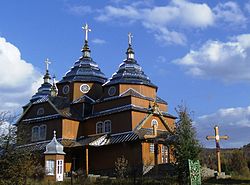
Klymets (Ukrainian: Климе́ць, Polish: Klimiec; German: Klimetz) is a selo (village) in Stryi Raion, Lviv Oblast, of western Ukraine. More specifically, it is located in the Ukrainian Carpathians, within the limits of the Eastern Beskids (Skole Beskids) in southwestern part of the oblast. Klymets belongs to Kozova rural hromada, one of the hromadas of Ukraine.[1] It is situated 149 kilometres (93 mi) from the regional center Lviv, 40 kilometres (25 mi) from the district center Skole, and 113 kilometres (70 mi) from Uzhhorod.
Local government is administered by the Klymetska village council. [2]
- ^ "Козовская громада" (in Russian). Портал об'єднаних громад України.
- ^ Климецька сільська рада (in Ukrainian)

