Back نایتس لندینق، کالیفورنیا AZB Найтс-Лендинг (Калифорни) CE Knights Landing CEB Knights Landing Spanish Knights Landing (Kalifornia) Basque نایتس لندینگ، کالیفرنیا Persian Knights Landing French Knights Landing (Kalifornija) Croatian Knights Landing Italian 나이츠랜딩 Korean
Knights Landing | |
|---|---|
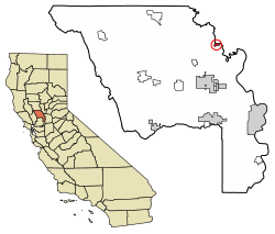
 Location of Knights Landing in Yolo County, California | |
| Coordinates: 38°47′59″N 121°43′06″W / 38.79972°N 121.71833°W | |
| Country | |
| State | |
| County | Yolo County |
| Area | |
| • Total | 1.298 km2 (0.501 sq mi) |
| • Land | 1.298 km2 (0.501 sq mi) |
| • Water | 0 km2 (0 sq mi) 0% |
| Elevation | 11 m (36 ft) |
| Population (2010) | |
| • Total | 995 |
| • Density | 770/km2 (2,000/sq mi) |
| FIPS code | 06-38800 |
Knights Landing (formerly, Baltimore and East Grafton) is a census-designated place in Yolo County, California, United States, founded by William Knight. It is located on the Sacramento River around 25 miles northwest of Sacramento in the northeastern portion of the county. Knights Landing's ZIP Code is 95645 and its area code 530. It lies at an elevation of 36 feet (11 m). The 2010 census reported that Knights Landing had a population of 995.
