Back نايتسبريدج Arabic نایتسبریج AZB Knightsbridge Catalan Knightsbridge Danish Knightsbridge (Stadtteil) German Knightsbridge Spanish نایتسبریج Persian Knightsbridge Finnish Knightsbridge French Knightsbridge Frisian
| Knightsbridge | |
|---|---|
 | |
Location within Greater London | |
| Population | 9,270 (2011 Census. Knightsbridge and Belgravia Ward)[1] |
| OS grid reference | TQ275797 |
| London borough | |
| Ceremonial county | Greater London |
| Region | |
| Country | England |
| Sovereign state | United Kingdom |
| Post town | LONDON |
| Postcode district | SW1X, SW3, SW7 |
| Dialling code | 020 |
| Police | Metropolitan |
| Fire | London |
| Ambulance | London |
| UK Parliament | |
| London Assembly | |
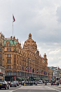
Knightsbridge is a residential and retail district in central London,[2] south of Hyde Park. It is identified in the London Plan as one of two international retail centres in London, alongside the West End.[3] Knightsbridge is also the name of the roadway which runs near the south side of Hyde Park from Hyde Park Corner.
Knightsbridge is an affluent district in London with a rich history and high property prices. The name has Old English origins, meaning "bridge of the young men or retainers." The area was initially divided between local authorities and has been home to several parishes. Knightsbridge has been associated with exclusive shops including Harrod’s and Harvey Nichols, banks catering to wealthy individuals, renowned restaurants, and high-end salons. Property prices in the district are among the highest in the world, with the most expensive apartment at One Hyde Park selling for £100 million in 2007.[4]
Knightsbridge is located between Exhibition Road and Sloane Street, with its southern border along Brompton Road, Beauchamp Place, and the western section of Pont Street. The district has been a target for high-profile crimes throughout history, including the Spaghetti House siege, the Walton's Restaurant bombing, and the Knightsbridge Security Deposit robbery. It is served by the Knightsbridge station on the Piccadilly line and the Sloane Square station on the District and Circle lines.
- ^ "City of Westminster ward population 2011". Neighbourhood Statistics. Office for National Statistics. Archived from the original on 21 October 2016. Retrieved 15 October 2016.
- ^ "London's Places" (PDF). The London Plan. Greater London Authority. 2011. p. 46. Archived from the original (PDF) on 6 September 2015. Retrieved 27 May 2014.
- ^ Mayor of London (2008). "Central activities zone policies". London Plan. Greater London Authority. Archived from the original on 28 May 2014. Retrieved 27 May 2014.
- ^ "The Shadowy Residents of One Hyde Park—And How the Super-Wealthy Are Hiding Their Money". Vanity Fair. 13 March 2013. Retrieved 28 September 2023.
