Back مقاطعة نوكس (أوهايو) Arabic ناکس بؤلگهسی، اوهایو AZB Knox County, Ohio BAR Нокс (окръг, Охайо) Bulgarian কক্স কাউন্টি, ওহাইও BPY Knox Gông (Ohio) CDO Knox County (kondado sa Tinipong Bansa, Ohio) CEB Knox County, Ohio Welsh Knox County (Ohio) Danish Knox County (Ohio) German
Knox County | |
|---|---|
 The Knox County Courthouse in 2013 | |
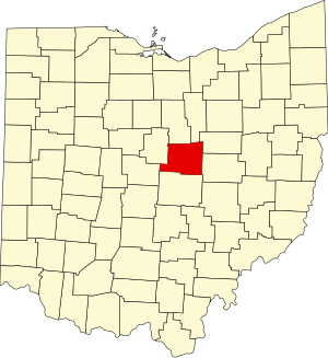
 Location within the U.S. state of Ohio | |
 Ohio's location within the U.S. | |
| Coordinates: 40°23′N 82°28′W / 40.38°N 82.47°W | |
| Country | |
| State | |
| Founded | March 1, 1808[1] |
| Named for | Henry Knox |
| Seat | Mount Vernon |
| Largest city | Mount Vernon |
| Area | |
| • Total | 530 sq mi (1,400 km2) |
| • Land | 525 sq mi (1,360 km2) |
| • Water | 4.1 sq mi (11 km2) 0.8% |
| Population (2020) | |
| • Total | 62,721 |
| • Estimate (2023) | 63,320 |
| • Density | 120/sq mi (46/km2) |
| Time zone | UTC−5 (Eastern) |
| • Summer (DST) | UTC−4 (EDT) |
| Congressional district | 12th |
| Website | www |
Knox County is a county located in the U.S. state of Ohio. As of the 2020 census, the population was 62,721.[2] Its county seat is Mount Vernon.[3] The county is named for Henry Knox, an officer in the American Revolutionary War who was later the first Secretary of War.[4] Knox County comprises the Mount Vernon, OH Micropolitan Statistical Area, which is also included in the Columbus-Marion-Zanesville, OH Combined Statistical Area.
- ^ "Ohio County Profiles: Knox County" (PDF). Ohio Department of Development. Archived from the original (PDF) on June 21, 2007. Retrieved April 28, 2007.
- ^ 2020 census
- ^ "Find a County". National Association of Counties. Archived from the original on May 31, 2011. Retrieved June 7, 2011.
- ^ Gannett, Henry (1905). The Origin of Certain Place Names in the United States. Government Printing Office. pp. 177.

