Back كوكشيتو Arabic كوكشيتو ARZ Kökşetau Azerbaijani Күксәтау Bashkir Какшэтаў Byelorussian Какшатаў BE-X-OLD Кокшетау Bulgarian Kokxetau Catalan Коькшетау CE Kokshetau (kapital sa lalawigan sa Khasakstan) CEB
Kokshetau
Kökşetau (Kazakh) | |
|---|---|
| Official Cyrillic transcription(s) | |
| • Kazakh Cyrillic | Көкшетау |
| • Russian Cyrillic | Кокшета́у |
Skyline of Kokshetau with the city's central Abylai Khan Square in the foreground Historical center of Kokshetau | |
|
| |
| Nickname: | |
| Anthem: none | |
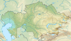
Location of Kokshetau in Kazakhstan | |
| Coordinates: 53°17′N 69°23′E / 53.283°N 69.383°E | |
| Country | |
| Region | Akmola Region |
| Founded | 19th century (29 April 1824) |
| City status since | 1895 |
| Government | |
| • Akim (mayor) | Bauyrzhan Gaisa[1][2] |
| Area | |
| • City and administrative centre of Akmola Region | 234 km2 (90 sq mi) |
| • Urban | 425 km2 (164 sq mi) |
| Elevation | 234 m (768 ft) |
| Population | |
| • City and administrative centre of Akmola Region | 150,649 |
| • Rank | 18th in Kazakhstan 1st in Akmola Region |
| • Density | 624/km2 (1,620/sq mi) |
| • Urban | 165,153 |
| Demonym(s) | Көкшетаулық (kk) Кокшетауцы (ru) Кокшетауец (ru, male) Кокшетаука (ru, female) |
| Demographics (2022 est.)[5] | |
| • Kazakhs | 59.34% |
| • Russians | 28.38% |
| • Ukrainians | 2.75% |
| • Tatars | 2.22% |
| • Germans | 1.98% |
| • Poles | 1.35% |
| • Ingush | 1.06% |
| • Other | 2.92% |
| Time zone | UTC+05:00 (Kazakhstan Time) |
| Postal code | 020000–020010 |
| Area code | +7-7162 |
| Vehicle registration | 03 (region) (before 2012: C – on older plates) |
| Sister cities | Waukesha, Wisconsin |
| Climate | BSk |
| Highways | |
| International airports | Kokshetau (KOV) |
| Major railway stations | |
| KATO ID | 111010000[6] |
| Website | www.kokshetau.kz |
Kokshetau (Kazakh: Көкшетау, romanized: Kökşetau; [kɵkʂʲetɑw] , lit. 'Blueish Mountain/Smoky-Blue Mountain'; Russian: Кокшетау, IPA: [kəkʂɛ'taʊ]), formerly known as Kokchetav (Russian: Кокчетав, [kəktɕe'tav]; the official name between 1868 and 1993) is a lakeside city in northern Kazakhstan and the capital of Akmola Region (oblys), which stretches along the southern shore of Lake Kopa, lying in the north of Kokshetau Hills, a northern subsystem of the Kokshetau Uplands (Saryarka) and the southern edge of the Ishim Plain. It is named after the Mount Kokshe.
It was the administrative center of Kokshetau Region (oblast) from 1944 to 1991 as part of the Soviet Union and from 1991 as part of Kazakhstan to 1997 when it was abolished. It is also situated at the junction of the Trans-Kazakhstan and South Siberian railways. Kokshetau lies at an elevation of approximately 234 m (768 ft) above sea level. The climate of Kokshetau features hot summers and cold winters.
It has 150,649 inhabitants (2022 est.), up from 123,389 (1999 census), while Akmola Region had a total population of 738,587 (2019 est.), down from 1,061,820 (1989 census), making it the tenth most populous region in Kazakhstan.[7] The city's history has been influenced by people of many nations and religions. Kokshetau retains multiethnic population, with 59% ethnic Kazakhs (up from 36%), the rest being mostly 28% ethnic Russians (down from 42%) and other ethnic groups such as Ukrainians, Tatars and Germans. Kokshetau City Administration (area of 425 km2 [164 sq mi]), with a population of roughly 165,153 residents, includes one settlement administration (which consists of the work settlement of Stantsyonny) and the Krasnoyarsk rural district, which includes two rural settlements (the villages of Krasny Yar and Kyzyl-Zhuldyz).
The city is considered to have been founded in 1824 as a military fortress, while it was granted city status in 1895. It was the centre of Kokshetau Region, which was abolished in 1997. It is well known for its nature and tourist sites, such as Burabay and Zerendi, among others. The city's main football team is FC Okzhetpes. Kokshetau is about 185 km (115 mi) from Petropavl, 300 km (190 mi) northwest of the national capital Astana along the A1, 318 km (198 mi) from Omsk along the A13, and 384 km (239 mi) from Kostanay. The city is served by Kokshetau Airport (KOV). The akim (mayor) is Bauyrzhan Gaisa from the Amanat Party.
Kokshetau is an important economic, educational, and cultural centre of the Akmola Region. Attractions in and around Kokshetau include Akmola Regional Museum of History and Local Lore, Bukpa Hill, Kokshetau City Park, Kokshetau City History Museum, Museum of Literature and Art. The northwest entrance to Burabay National Park (Kazakh: Burabai memlekettık ūlttyq tabiği parkı) and Burabay spa town is a little over 43 miles (70 km) from Kokshetau. Kokshetau was awarded the title Kazakhstan City of Culture for the year 2021.[8][9]
- ^ Supported unanimously
- ^ "New akim of Kokshetau appointed". 25 March 2021. Retrieved 25 October 2022.
- ^ "Results Of The 2009 National Population Census Of The Republic Of Kazakhstan Analytical Report" (PDF). The Agency On Statistics of the Republic of Kazakhstan.
- ^ "Birth and death rates in January-March 2010-2011". Archived from the original on 26 May 2011. Retrieved 22 October 2009.
- ^ "Population of the Republic of Kazakhstan by individual ethnic groups at the beginning of 2020". Statistics Committee of the Ministry of National Economy of the Republic of Kazakhstan. Retrieved 28 April 2020.
- ^ "KATO base". Statistics Committee of the Ministry of National Economy of the Republic of Kazakhstan. Retrieved 19 June 2017.
- ^ "Cities and towns in Qаzаqstаn". Population Statistics. Retrieved 28 December 2022.
- ^ "Kokshetau Named Cultural Capital of Kazakhstan in 2021". 20 May 2021. Retrieved 21 May 2021.
- ^ "Kokshetau - the cultural capital of Kazakhstan". 19 May 2021. Retrieved 28 May 2021.


