Kolvereid Municipality
Kolvereid herred | |
|---|---|
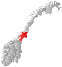
 Nord-Trøndelag within Norway | |
 Kolvereid within Nord-Trøndelag | |
| Coordinates: 64°51′55″N 11°36′16″E / 64.86528°N 11.60444°E | |
| Country | Norway |
| County | Nord-Trøndelag |
| District | Namdalen |
| Established | 1 Jan 1838 |
| • Created as | Formannskapsdistrikt |
| Disestablished | 1 Jan 1964 |
| • Succeeded by | Nærøy Municipality |
| Administrative centre | Kolvereid |
| Area (upon dissolution) | |
| • Total | 433 km2 (167 sq mi) |
| Population (1964) | |
| • Total | 2,426 |
| • Density | 5.6/km2 (15/sq mi) |
| Time zone | UTC+01:00 (CET) |
| • Summer (DST) | UTC+02:00 (CEST) |
| ISO 3166 code | NO-1752[1] |
Kolvereid is a former municipality in the old Nord-Trøndelag county, Norway. The 433-square-kilometre (167 sq mi) municipality existed from 1838 until its dissolution in 1964. The municipality encompassed the central part of what is now the municipality of Nærøysund in Trøndelag county. The municipality included both sides of the central part of the Folda fjord. The administrative centre was the village of Kolvereid where the Kolvereid Church is located.[2]
- ^ Bolstad, Erik; Thorsnæs, Geir, eds. (26 January 2023). "Kommunenummer". Store norske leksikon (in Norwegian). Kunnskapsforlaget.
- ^ Rosvold, Knut A., ed. (12 April 2018). "Kolvereid". Store norske leksikon (in Norwegian). Kunnskapsforlaget. Retrieved 29 April 2018.
