Back نهر كوتيناي Arabic نهر كوتيناى ARZ کووتنای چایی AZB Кутни (река) Bulgarian Riu Kootenay Catalan Kootenay River CEB Kootenay (řeka) Czech Кутеней (юханшыв) CV Kootenay River German Río Kootenay Spanish
| Kootenay River Kootenai River | |
|---|---|
 The Kootenai River at Libby, Montana | |
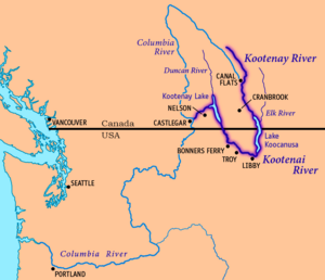
 Map of the Kootenay/Kootenai River, its main tributaries and lakes, and major cities. | |
| Native name | |
| Location | |
| Countries | Canada, United States |
| Province | British Columbia |
| States | Montana, Idaho |
| Physical characteristics | |
| Source | South flank of Castle Mountain |
| • location | Mount Hungabee, Kootenay National Park, British Columbia, Canada |
| • coordinates | 51°18′53.6″N 116°17′10.6″W / 51.314889°N 116.286278°W[1] |
| • elevation | 2,261 m (7,418 ft)[1] |
| Mouth | Columbia River |
• location | Castlegar, British Columbia, Canada |
• coordinates | 49°19′0″N 117°39′4″W / 49.31667°N 117.65111°W[2] |
• elevation | 420 m (1,380 ft)[3] |
| Length | 780 km (480 mi)[4] |
| Basin size | 50,298 km2 (19,420 sq mi)[3] |
| Discharge | |
| • location | Columbia River at Castlegar, BC (rates given for Kootenay Lake near Corra Linn Dam[5][6] some 10 miles upstream) |
| • average | 782 m3/s (27,600 cu ft/s)[5][6] |
| • minimum | 104 m3/s (3,700 cu ft/s) |
| • maximum | 4,930 m3/s (174,000 cu ft/s) |
| Basin features | |
| Tributaries | |
| • left | Palliser River, White River, Bull River, Elk River, Fisher River, Tobacco River, Lake Creek |
| • right | St. Mary River, Yaak River, Moyie River, Goat River, Duncan River, Slocan River |
 | |
The Kootenay River[7] or Kootenai River[2] is a major river of the Northwest Plateau in southeastern British Columbia, Canada, and northern Montana and Idaho in the United States. It is one of the uppermost major tributaries of the Columbia River, the largest North American river that empties into the Pacific Ocean. The Kootenay River runs 781 kilometres (485 mi) from its headwaters in the Kootenay Ranges of the Canadian Rockies, flowing from British Columbia's East Kootenay region into northwestern Montana, then west into the northernmost Idaho Panhandle and returning to British Columbia in the West Kootenay region, where it joins the Columbia at Castlegar.
The river is known as the "Kootenay" in Canada and by the Ktunaxa Nation,[7] and as the "Kootenai" in the United States and by the Confederated Salish and Kootenai Tribes and Kootenai Tribe of Idaho.[2] Fed mainly by glaciers and snowmelt, the river drains a rugged, sparsely populated region of more than 50,000 km2 (19,000 sq mi), of which over 70 percent is in Canada. From its headwaters to its confluence with the Columbia River, the Kootenay descends more than 2,000 metres (6,600 ft). At their confluence, the Columbia and Kootenay are similar in length, drainage area, and volume, but less of the Kootenay is impounded in reservoirs and thus it has more free-flowing stretches with rapids and falls. Part of the lower Kootenay forms Kootenay Lake, one of the largest natural lakes in British Columbia.
The Ktunaxa (Kootenai) were the first people to live along the Kootenay River. For hundreds of years, they hunted and fished on the river, quite isolated from neighboring tribes. In the 19th century, Canadian explorer David Thompson became the first recorded European to reach the Kootenay and established trading posts throughout the region. A gold rush followed by silver and galena strikes in the late 19th century drew thousands of miners and settlers to the region, bringing developments such as railroads and steamboat navigation. The Doukhobors, a Russian religious sect, established a short-lived colony, Brilliant, at the Kootenay's mouth; subsequently dispersing into many settlements, they contributed to the region's timber and agricultural industries.
As with many Pacific Northwest rivers, many dams were built on the Kootenay in the 20th century to generate electricity and protect against floods and droughts. Water levels of Kootenay Lake are artificially regulated, and numerous hydroelectric dams block the river between Kootenay Lake and the Columbia River. Upstream of Kootenay Lake, most of the river is free-flowing with the exception of the Libby Dam in Montana, which forms Lake Koocanusa.
- ^ a b Source elevations and coordinates derived from Google Earth using data from Canadian topo maps
- ^ a b c U.S. Geological Survey Geographic Names Information System: Kootenai River
- ^ a b "The Rivers - Stories". Balance of Power. 2007. Archived from the original on November 6, 2011. Retrieved September 3, 2008.
- ^ Cite error: The named reference
overviewwas invoked but never defined (see the help page). - ^ a b "Kootenay Lake Outflow Near Corra Linn – Monthly Mean Discharge". HYDAT Archived Hydrometric Data. Environment Canada. 1937–2010. Archived from the original on 2012-04-21. Retrieved 2011-11-25.
- ^ a b "Kootenai River Basin - Hydrology". International Alliance for Water Quality and Aquatic Resources. Kootenai River Network, Inc. 2010-03-14. Archived from the original on September 6, 2007. Retrieved 2010-03-25.
- ^ a b "Kootenay River". BC Geographical Names. Retrieved 2010-04-13.