Back Kyogle (rehiyon) CEB Kyogle Council German Conseil de Kyogle French Municipalità di Kyogle Italian Kyogle Council Dutch Kyogle Council Swedish
| Kyogle Council New South Wales | |||||||||||||||
|---|---|---|---|---|---|---|---|---|---|---|---|---|---|---|---|
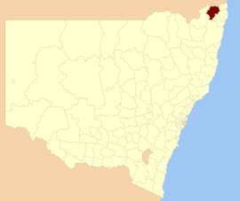
 Location in New South Wales | |||||||||||||||
| Population |
| ||||||||||||||
| • Density | 2.4909/km2 (6.452/sq mi) | ||||||||||||||
| Area | 3,589 km2 (1,385.7 sq mi)[3] | ||||||||||||||
| Mayor | Kylie Thomas, (Independent) | ||||||||||||||
| Council seat | Kyogle | ||||||||||||||
| Region | Northern Rivers | ||||||||||||||
| State electorate(s) | Lismore[4] | ||||||||||||||
| Federal division(s) | Page | ||||||||||||||
 | |||||||||||||||
| Website | Kyogle Council | ||||||||||||||
| |||||||||||||||
Kyogle Council is a local government area in the Northern Rivers region of New South Wales, Australia.
The council services an area of 3,589 square kilometres (1,386 sq mi) and is located adjacent to the Summerland Way and the North Coast railway line, within two hours drive from Brisbane and one hour from the Queensland Gold Coast and the NSW coastal communities of Byron Bay, Ballina and Tweed Heads. Kyogle Council comprises a large and diverse region with natural attributes, including the Border Ranges National Park and other world heritage listed areas, and cultural features.[5]
The mayor of Kyogle Council is Clr. Kylie Thomas.
In 2015, Kyogle Council was deemed 'not fit for future' by the New South Wales government's Independent Pricing and Regulatory Tribunal and was urged to merge with a nearby council,[6] although the NSW government backflipped later in 2015 and allowed the council to continue in its current form.[7]
- ^ Australian Bureau of Statistics (27 June 2017). "Kyogle (A)". 2016 Census QuickStats. Retrieved 8 December 2017.
- ^ "3218.0 – Regional Population Growth, Australia, 2017–18". Australian Bureau of Statistics. 27 March 2019. Retrieved 27 March 2019. Estimated resident population (ERP) at 30 June 2018.
- ^ "Kyogle Council". Department of Local Government. Retrieved 19 November 2006.
- ^ "Lismore Electoral District". New South Wales Electoral Commission. Retrieved 19 November 2006.[permanent dead link]
- ^ "Annual Report 2014/2015" (PDF). Kyogle Council. 9 November 2015. p. 4. Retrieved 28 May 2016.
- ^ "Tweed, Kyogle and Clarence Valley not 'fit for the future'". ABC News. 20 October 2015.
- ^ "Kyogle Council avoids forced amalgamation". ABC News. 18 December 2015.