Back Partido de La Plata AST Partit de La Plata Catalan Partido de La Plata CEB Partido La Plata German Partio La Plata Esperanto Partido de La Plata Spanish لا پلاتا پارتیدو Persian La Plata (partido) French La Plata partido Hungarian Partido di La Plata Italian
La Plata
Partido de La Plata | |
|---|---|
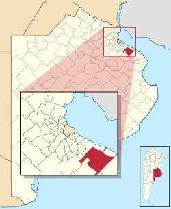
 location of La Plata Partido in Buenos Aires Province | |
| Coordinates: 34°55′S 57°17′W / 34.917°S 57.283°W | |
| Country | Argentina |
| Established | November 19, 1882 |
| Founded by | Dardo Rocha |
| Seat | La Plata |
| Government | |
| • Mayor | Julio Alak (PJ-UP) |
| Area | |
| • Total | 926 km2 (358 sq mi) |
| Population | |
| • Total | 654,324 |
| • Density | 710/km2 (1,800/sq mi) |
| Demonym | Platense |
| Postal Code | B1900 |
| Area Code | 0221 |
| Website | laplata.gob.ar |
La Plata is a partido in Buenos Aires Province, Argentina, some 60 kilometres (37 mi) southeast of the city of Buenos Aires.
It has an area of 926 km2 (358 sq mi), and a population of 654,324 (2010 census [INDEC]). Its capital is La Plata, which also serves as the capital of the province. La Plata is the centre of the Greater La Plata urban conurbation.
Many of the suburbs have train links to both Buenos Aires and La Plata, and also good road access via the Buenos Aires-La Plata toll highway. There is also an extensive network of buses serving the Greater La Plata area.
The city of Manuel B. Gonnet features the República de los Niños theme park.
Several parks lie along the Camino General Belgrano road, which crosses the partido north-to-south, notably the Parque Pereyra Iraola.
