Back بحيره مانيتوبا ARZ Manitoba gölü Azerbaijani Манітоба (возера) Byelorussian Манитоба (езеро) Bulgarian Llac Manitoba Catalan Lake Manitoba CEB Manitoba (jezero) Czech Манитоба (кӳлĕ) CV Manitobasee German Manitoba Lago Esperanto
| Lake Manitoba | |
|---|---|
 | |
| Location | Manitoba |
| Coordinates | 50°59′N 98°48′W / 50.983°N 98.800°W[1] |
| Lake type | Glacial lake |
| Primary inflows | Waterhen River Whitemud River |
| Primary outflows | Fairford River |
| Catchment area | 54,630 km2 (21,090 sq mi) |
| Basin countries | Canada |
| Max. length | 200 km (120 mi) |
| Max. width | 45 km (28 mi) |
| Surface area | 4,624 km2 (1,785 sq mi) |
| Max. depth | 7 m (23 ft) |
| Water volume | 14.1 km3 (3.4 cu mi) |
| Residence time | North basin: 2 years; South basin: 28 years [2] |
| Salinity | 3.5‰ (hyposaline)[3] |
| Surface elevation | 247 m (812 ft) |
| Settlements | Fairford, Steep Rock, St. Laurent, Sandy Bay |
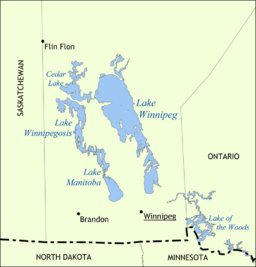
Lake Manitoba (French: Lac Manitoba[4]) is the 14th largest lake in Canada and the 33rd largest lake in the world with a total area of 4,624 square kilometres (1,785 sq mi). It is located within the Canadian province of Manitoba about 75 kilometres (47 mi) northwest of the province's capital, Winnipeg, at 50°59′N 98°48′W / 50.983°N 98.800°W[1].
- ^ a b "Lake Manitoba". Geographical Names Data Base. Natural Resources Canada.
- ^ "Archived copy" (PDF). Archived from the original (PDF) on 3 March 2016. Retrieved 2 September 2017.
{{cite web}}: CS1 maint: archived copy as title (link) - ^ Last, William M.; Slezak, Laurie A. (1988). "The salt lakes of western Canada: A paleolimnological overview" (PDF). Hydrobiologia. 158: 301–316. doi:10.1007/BF00026286. S2CID 21394879 – via cc.umanitoba.ca.
- ^ "Lac Manitoba". Geographical Names Data Base. Natural Resources Canada.

