Back Ontariomeer Afrikaans بحيرة أونتاريو Arabic ܝܡܬܐ ܕܐܘܢܛܪܝܘ ARC بحيرة اونتاريو ARZ Llagu Ontario AST Ontario gölü Azerbaijani Онтарио (күл) Bashkir Антарыа (возера) Byelorussian Антарыё (возера) BE-X-OLD Онтарио (езеро) Bulgarian
| Lake Ontario | |
|---|---|
| Niigaani-gichigami (Ojibwe) | |
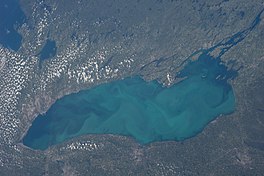
 Lake Ontario seen from the International Space Station on August 24, 2013. The cloudy yellowish substance is algae bloom. | |
 | |
| Location | North America |
| Group | Great Lakes |
| Coordinates | 43°42′N 77°54′W / 43.7°N 77.9°W |
| Lake type | Glacial |
| Etymology | Ontarí:io, a Huron (Wyandot) word meaning "great lake" |
| Primary inflows | Niagara River |
| Primary outflows | St. Lawrence River |
| Catchment area | 24,720 sq mi (64,000 km2)[5] |
| Basin countries | Canada and United States |
| Max. length | 193 mi (311 km)[6] |
| Max. width | 53 mi (85 km)[6] |
| Surface area | 7,323 sq mi (18,970 km2)[5] |
| Average depth | 283 ft (86 m)[6][7] |
| Max. depth | 802 ft (244 m)[6][7] |
| Water volume | 391.4 cu mi (1,631 km3)[6] |
| Residence time | 6 years |
| Shore length1 | 634 mi (1,020 km) plus 78 mi (126 km) for islands[8] |
| Surface elevation | 243 ft (74 m)[6] |
| Settlements | Toronto, Ontario Mississauga, Ontario Hamilton, Ontario Rochester, New York |
| References | [7] |
| 1 Shore length is not a well-defined measure. | |
Lake Ontario is one of the five Great Lakes of North America. It is bounded on the north, west, and southwest by the Canadian province of Ontario, and on the south and east by the U.S. state of New York. The Canada–United States border spans the centre of the lake.
The Canadian cities of Hamilton, Kingston, Mississauga, and Toronto are located on the lake's northern shorelines, while the Canadian city of St. Catharines and the American city of Rochester are located on the south shore. In the Huron language, the name Ontarí'io means "great lake". Its primary inlet is the Niagara River from Lake Erie. The last in the Great Lakes chain, Lake Ontario serves as the outlet to the Atlantic Ocean via the Saint Lawrence River, comprising the western end of the Saint Lawrence Seaway. The Long Sault control dam, primarily along with the Moses-Saunders Power Dam regulates the water level of the lake.[9]
- ^ Cite error: The named reference
GLBathOntwas invoked but never defined (see the help page). - ^ Cite error: The named reference
GLBathErwas invoked but never defined (see the help page). - ^ Cite error: The named reference
GLOBEwas invoked but never defined (see the help page). - ^ Cite error: The named reference
NOAA_GLERLwas invoked but never defined (see the help page). - ^ a b Cite error: The named reference
EPAphysicalwas invoked but never defined (see the help page). - ^ a b c d e f Cite error: The named reference
EPAwas invoked but never defined (see the help page). - ^ a b c Wright 2006, p. 64.
- ^ Shorelines of the Great Lakes Archived April 5, 2015, at the Wayback Machine
- ^ Armstrong, Leslie (August 14, 2014). "Great Lakes Water Levels Rebound Thanks to Prolonged Winter". Toronto Star.
