Back مقاطعة لين (كانساس) Arabic Lane County, Kansas BAR Лейн (окръг, Канзас) Bulgarian লেন কাউন্টি, ক্যানসাস BPY Lane Gông (Kansas) CDO Лейн (гуо, Канзас) CE Lane County (kondado sa Tinipong Bansa, Kansas) CEB Lane County (Kansas) Czech Lane County, Kansas Welsh Lane County (Kansas) German
Lane County | |
|---|---|
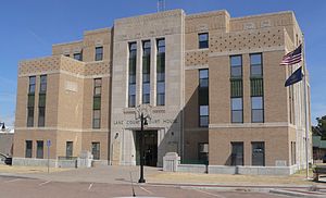
 Lane County Courthouse in Dighton (2015) | |
 Location within the U.S. state of Kansas | |
 Kansas's location within the U.S. | |
| Coordinates: 38°28′00″N 100°28′01″W / 38.4667°N 100.467°W | |
| Country | |
| State | |
| Founded | March 20, 1873 |
| Named for | James H. Lane |
| Seat | Dighton |
| Largest city | Dighton |
| Area | |
| • Total | 718 sq mi (1,860 km2) |
| • Land | 717 sq mi (1,860 km2) |
| • Water | 0.2 sq mi (0.5 km2) 0.03% |
| Population | |
| • Total | 1,574 |
| • Estimate (2021)[2] | 1,565 |
| • Density | 2.2/sq mi (0.8/km2) |
| Time zone | UTC−6 (Central) |
| • Summer (DST) | UTC−5 (CDT) |
| Congressional district | 1st |
| Website | lanecountyks.org |
Lane County is a county located in the U.S. state of Kansas. Its county seat is Dighton,[3] the only incorporated city in the county. As of the 2020 census, the county population was 1,574,[1] making it the third-least populous county in Kansas. The county was named after James Lane, a leader of the Jayhawker abolitionist movement and served as one of the first U.S. senators from Kansas.[4]
- ^ a b "QuickFacts; Lane County, Kansas; Population, Census, 2020 & 2010". United States Census Bureau. Archived from the original on August 18, 2021. Retrieved August 17, 2021.
- ^ "Annual Estimates of the Resident Population for Counties: April 1, 2020 to July 1, 2021". Retrieved October 23, 2022.
- ^ "Find a County". National Association of Counties. Retrieved June 7, 2011.
- ^ Gannett, Henry (1905). The Origin of Certain Place Names in the United States. Government Printing Office. pp. 180.