Back لانسدال (بنسيلفانيا) Arabic Лансдейл (Пенсильвани) CE Lansdale CEB Lansdale, Pennsylvania Welsh Lansdale (Pennsylvania) German Lansdale Spanish Lansdale (Pennsylvania) Basque Lansdale French Lansdale, Pennsilvani HT Lansdale Italian
Lansdale | |
|---|---|
 Main Street in Lansdale | |
| Motto: Life in Motion | |
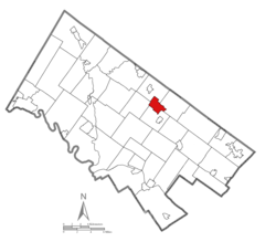
 Location of Lansdale in Montgomery County, Pennsylvania | |
| Coordinates: 40°14′31″N 75°17′03″W / 40.24194°N 75.28417°W | |
| Country | United States |
| State | Pennsylvania |
| County | Montgomery |
| Government | |
| • Type | Council-manager |
| • Mayor | Garry Herbert |
| Area | |
| • Total | 2.99 sq mi (7.75 km2) |
| • Land | 2.99 sq mi (7.75 km2) |
| • Water | 0.00 sq mi (0.00 km2) |
| Elevation | 361 ft (110 m) |
| Population | |
| • Total | 18,773 |
| • Density | 6,272.30/sq mi (2,422.12/km2) |
| Time zone | UTC-5 (EST) |
| • Summer (DST) | UTC-4 (EDT) |
| ZIP Code | 19446 |
| Area codes | 215, 267 and 445 |
| FIPS code | 42-41432 |
| Website | www |
Lansdale is a borough in Montgomery County, Pennsylvania, United States. It is a densely-populated commuter town, with many residents traveling daily to Philadelphia using SEPTA Regional Rail's Lansdale/Doylestown Line. In 1900, 2,754 people lived here; in 1910, 3,551; and in 1940, 9,316 people were inhabitants of Lansdale. The population was 18,773 at the 2020 census.
Lansdale is the center of the North Penn Valley, a region which includes the surrounding townships and boroughs. It is located 27 miles (43 km) southeast of Allentown and 21 miles (34 km) north of Philadelphia.
- ^ "ArcGIS REST Services Directory". United States Census Bureau. Retrieved October 12, 2022.
- ^ Cite error: The named reference
USCensusDecennial2020CenPopScriptOnlywas invoked but never defined (see the help page).


