Back لارفيك Arabic لارفيك ARZ Larvik AST Ларвік Byelorussian Лярвік BE-X-OLD Ларвик Bulgarian Larvik BJN লারভিক BPY Larvik Catalan Larvik (munisipyo) CEB
Larvik Municipality
Larvik kommune | |
|---|---|
 Larvik town square, 2008 | |
| Nickname(s): Bakkebyen, The Hilly City | |
 Vestfold within Norway | |
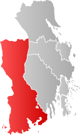
 Larvik within Vestfold | |
| Coordinates: 59°4′52″N 10°0′59″E / 59.08111°N 10.01639°E | |
| Country | Norway |
| County | Vestfold |
| Established | 1 Jan 1838 |
| • Created as | Formannskapsdistrikt |
| Administrative centre | Larvik |
| Government | |
| • Mayor (2023) | Birgitte Gulla Løken (H) |
| Area | |
| • Total | 812.88 km2 (313.85 sq mi) |
| • Land | 771.41 km2 (297.84 sq mi) |
| • Water | 41.47 km2 (16.01 sq mi) 5.1% |
| • Rank | #140 in Norway |
| Population (2023) | |
| • Total | 48,246 |
| • Rank | #21 in Norway |
| • Density | 62.5/km2 (162/sq mi) |
| • Change (10 years) | |
| Demonyms | Larviking Larviker Larvikar[1] |
| Official language | |
| • Norwegian form | Neutral |
| Time zone | UTC+01:00 (CET) |
| • Summer (DST) | UTC+02:00 (CEST) |
| ISO 3166 code | NO-3909[3] |
| Website | Official website |
Larvik (Urban East Norwegian: [ˈlɑ̂rviːk] )[4] is a municipality in Vestfold county, Norway. It is located in the traditional district of Vestfold. The administrative centre of the municipality is the city of Larvik. Other main population centres in the municipality include the town of Stavern and the villages of Gjone, Helgeroa, Hem, Kjose, Kvelde, Nevlunghavn, Skinmo, Svarstad, Ula, Verningen, and Tjøllingvollen.[5]
The 813-square-kilometre (314 sq mi) municipality is the 140th largest by area out of the 356 municipalities in Norway. Larvik is the 21st most populous municipality in Norway with a population of 48,246. The municipality's population density is 62.5 inhabitants per square kilometre (162/sq mi) and its population has increased by 5.9% over the previous 10-year period.[6][7]
The city of Larvik achieved market town status in 1671, but it did not become a self-governing municipality until 1 January 1838 when the formannskapsdistrikt law went into effect.[8]
Larvik is known as the hometown of Thor Heyerdahl.[9]: 30 It is also home to Bøkeskogen, the northernmost beech tree forest in the world. Larvik is the home of Norway's only natural mineral water spring, Farriskilden.[8][10] Farris Bad, located in Larvik, has been described as one of the best spas in Europe.[11] It has the largest spa department in Scandinavia.[12]
- ^ "Navn på steder og personer: Innbyggjarnamn" (in Norwegian). Språkrådet.
- ^ "Forskrift om målvedtak i kommunar og fylkeskommunar" (in Norwegian). Lovdata.no.
- ^ Bolstad, Erik; Thorsnæs, Geir, eds. (26 January 2023). "Kommunenummer". Store norske leksikon (in Norwegian). Kunnskapsforlaget.
- ^ Berulfsen, Bjarne (1969). Norsk Uttaleordbok (in Norwegian). Oslo: H. Aschehoug & Co (W Nygaard). p. 194.
- ^ Thorsnæs, Geir; Lundbo, Sten; Mæhlum, Lars, eds. (15 August 2023). "Larvik". Store norske leksikon (in Norwegian). Kunnskapsforlaget. Retrieved 11 November 2023.
- ^ Statistisk sentralbyrå. "Table: 06913: Population 1 January and population changes during the calendar year (M)" (in Norwegian).
- ^ Statistisk sentralbyrå. "09280: Area of land and fresh water (km²) (M)" (in Norwegian).
- ^ a b Evensberget, Snorre (2014). DK Eyewitness Travel Guide: Norway. Penguin. p. 129. ISBN 9781465432469.
- ^ Lund, Arild; Jørgensen, Charlotte (2001). Larvik. Capella Media. ISBN 9788299606912.
- ^ Bertelsen, Hans Kristian (1998). Bli kjent med Vestfold / Become acquainted with Vestfold. Stavanger Offset AS. pp. 63–65. ISBN 9788290636017.
- ^ Ham, Anthony; Butler, Stuart (2015). Lonely Planet Norway. Lonely Planet. p. 91. ISBN 9781742202075.
- ^ "Farris Bad". VisitNorway.com.
