The topic of this article may not meet Wikipedia's notability guideline for geographic features. (January 2024) |
Lat Phrao
ลาดพร้าว | |
|---|---|
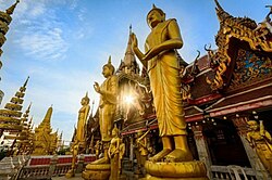
 Wat Lat Phrao temple | |
 Location in Lat Phrao district | |
| Coordinates: 13°49′01.5″N 100°36′55.3″E / 13.817083°N 100.615361°E | |
| Country | |
| Province | Bangkok |
| Khet | Lat Phrao |
| Area | |
| • Total | 15.102 km2 (5.831 sq mi) |
| Population (2021)[2] | |
| • Total | 89,135 |
| • Density | 5,902.20/km2 (15,286.6/sq mi) |
| Time zone | UTC+7 (ICT) |
| Postal code | 103801 |
| TIS 1099 | 10400 |
Lat Phrao (Thai: ลาดพร้าว, pronounced [lâːt pʰráːw]) is a khwaeng (subdistrict) of Lat Phrao district, Bangkok.
- ^ กองยุทธศาสตร์บริหารจัดการ. สำนักยุทธศาสตร์และประเมินผล. กรุงเทพมหานคร. "จำนวนประชากร พื้นที่ ความหนาแน่น จำนวนบ้าน จำแนกตามแขวง ในเขตกรุงเทพมหานคร 2563." สถิติกรุงเทพมหานครประจำปี 2563. Thai: ภาษาไทย
- ^ กรมการปกครอง. กระทรวงมหาดไทย. "สถิติจำนวนประชากรและบ้าน สถิติจำนวนประชากรและบ้าน ข้อมูล ปี 2564 พื้นที่ เขตลาดพร้าว." [ออนไลน์]. เข้าถึงได้จาก: https://stat.bora.dopa.go.th/stat/statnew/statyear/#/TableTemplate4/Area/statpop?yymm=64&ccDesc=กรุงเทพมหานคร&topic=statpop&ccNo=10&rcodeNo=1038&rcodeDesc=เขตลาดพร้าว 2565. สืบค้น 5 พฤษภาคม 2565. Thai: ภาษาไทย
