Back لاوريل (نبراسكا) Arabic لاوريل (سيدار) ARZ لرل، نبراسکا AZB Лоръл (Небраска) Bulgarian Laurel (Nebraska) Catalan Лорел (Небраска) CE Laurel (lungsod sa Tinipong Bansa, Nebraska) CEB Laurel (Nebraska) German Laurel (Nebraska) Spanish Laurel (Nebraska) Basque
Laurel, Nebraska | |
|---|---|
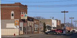
 Downtown Laurel looking east from 2nd and Elm St. prior to the Downtown Revitalization Project finished in 2021. | |
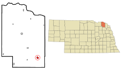
 Location of Laurel, Nebraska | |
| Coordinates: 42°25′44″N 97°05′49″W / 42.42889°N 97.09694°W | |
| Country | United States |
| State | Nebraska |
| County | Cedar |
| Government | |
| • Mayor | Keith Knudsen[1] |
| Area | |
| • Total | 1.35 sq mi (3.50 km2) |
| • Land | 1.35 sq mi (3.50 km2) |
| • Water | 0.00 sq mi (0.00 km2) |
| Elevation | 1,493 ft (455 m) |
| Population | |
| • Total | 975 |
| • Estimate (2021)[4] | 968 |
| • Density | 718.40/sq mi (277.37/km2) |
| Time zone | UTC-6 (Central (CST)) |
| • Summer (DST) | UTC-5 (CDT) |
| ZIP code | 68745 |
| Area code | 402 |
| FIPS code | 31-26350[5] |
| GNIS feature ID | 2395644[3] |
| Website | Official City website |
Laurel is a city in Cedar County, Nebraska located at the merger of Highway 20 and Highway 15 in the northeast corner of the state. Laurel sits roughly 40 miles east of Norfolk, Nebraska, west of Sioux City, Iowa, and south of Yankton, South Dakota. Wayne State College in Wayne, Nebraska is 15 miles south of Laurel. Its population was 975 at the 2020 census.[4]
- ^ "Contact Us / Government".
- ^ "ArcGIS REST Services Directory". United States Census Bureau. Retrieved September 18, 2022.
- ^ a b U.S. Geological Survey Geographic Names Information System: Laurel, Nebraska
- ^ a b c Bureau, US Census. "City and Town Population Totals: 2020-2021". Census.gov. US Census Bureau. Retrieved January 25, 2023.
{{cite web}}:|last1=has generic name (help) - ^ "U.S. Census website". United States Census Bureau. Retrieved January 31, 2008.