Back لاوريوم (ميشيغان) Arabic Laurium (lungsod sa Tinipong Bansa) CEB Laurium, Michigan Welsh Laurium (Míchigan) Spanish Laurium (Michigan) Basque Laurium (Michigan) French Laurium (Michigan) Italian Лауриум (Мичиган) Kazakh Лауриум Kirghiz Laurium (Michigan) LLD
Laurium, Michigan | |
|---|---|
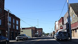
 Downtown Laurium | |
 Location within Houghton County | |
| Coordinates: 47°14′14″N 88°26′24″W / 47.23722°N 88.44000°W | |
| Country | United States |
| State | Michigan |
| County | Houghton |
| Township | Calumet |
| Incorporated | 1889 (as Calumet) 1895 (as Laurium) |
| Government | |
| • Type | Village council |
| • President | John Sullivan |
| • Village Manager | Ian Lewis |
| Area | |
| • Total | 0.65 sq mi (1.68 km2) |
| • Land | 0.65 sq mi (1.68 km2) |
| • Water | 0.00 sq mi (0.00 km2) |
| Elevation | 1,237 ft (377 m) |
| Population (2020) | |
| • Total | 1,864 |
| • Density | 2,872.11/sq mi (1,108.40/km2) |
| Time zone | UTC-5 (Eastern (EST)) |
| • Summer (DST) | UTC-4 (EDT) |
| ZIP code(s) | 49913 (Calumet) |
| Area code | 906 |
| FIPS code | 26-46360[3] |
| GNIS feature ID | 0630196[2] |
| Website | Official website |
Laurium Historic District | |
| Location | Roughly bounded by Calumet, Stable, N. Florida, and Isle Royale Sts., Laurium, Michigan |
| Coordinates | 47°14′10″N 88°26′26″W / 47.23611°N 88.44056°W |
| Built | 1877 |
| Architect | Paul Roehm, et al. |
| Architectural style | Late Victorian, Homestead-temple house |
| NRHP reference No. | 04001578[4] |
| Added to NRHP | January 31, 2005 |
Laurium (/ˈlɔːriəm/; LAW-ri-um or /ˈleɪriəm/ LAIR-i-um) is a village in Calumet Township, Houghton County in the U.S. state of Michigan, in the center of the Keweenaw Peninsula. The population was 1,977 at the 2010 census.
The village is mostly surrounded by Calumet Township, with a small portion bordering Schoolcraft Township on the east. The portion of Calumet Township south of Laurium is considered part of the Florida (or Florida Location) unincorporated community.[5]
- ^ "2020 U.S. Gazetteer Files". United States Census Bureau. Retrieved May 21, 2022.
- ^ a b U.S. Geological Survey Geographic Names Information System: Laurium, Michigan
- ^ "U.S. Census website". United States Census Bureau. Retrieved January 31, 2008.
- ^ "National Register Information System". National Register of Historic Places. National Park Service. March 13, 2009.
- ^ "Copper Country Survey Phase III" (PDF). National Park Service. 2012. Archived (PDF) from the original on November 7, 2016. Retrieved June 6, 2019.
