Back لورينسفيل (نيوجيرسي) Arabic لارنسویل، نیوجرسی AZB Lawrenceville (Nova Jersey) Catalan Lawrenceville (lungsod sa Tinipong Bansa, New Jersey) CEB Lawrenceville (New Jersey) German Lawrenceville (Nueva Jersey) Spanish لارنسویل، نیوجرسی Persian Lawrenceville (New Jersey) French Lawrenceville (New Jersey) Italian Лаурэнсвилл (Нью-Джерси) Kazakh
Lawrenceville, New Jersey | |
|---|---|
 The Hamill House was built in 1814 by Isaac Van Arsdale Brown, D.D. (1784–1861). This fieldstone schoolhouse was the original building for The Lawrenceville School and is a national landmark. | |
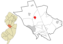
 Location in Mercer County and the state of New Jersey | |
Location in Mercer County Location in New Jersey | |
| Coordinates: 40°18′10″N 74°44′17″W / 40.302787°N 74.738004°W | |
| Country | |
| State | |
| County | Mercer |
| Township | Lawrence |
| Named for | Maidenhead, England |
| Area | |
| • Total | 1.04 sq mi (2.70 km2) |
| • Land | 1.04 sq mi (2.70 km2) |
| • Water | 0.00 sq mi (0.00 km2) 0.09% |
| Elevation | 184 ft (56 m) |
| Population | |
| • Total | 3,751 |
| • Density | 3,606.7/sq mi (1,392.6/km2) |
| Time zone | UTC−05:00 (Eastern (EST)) |
| • Summer (DST) | UTC−04:00 (Eastern (EDT)) |
| ZIP Code | 08648[4] |
| Area code | 609 |
| FIPS code | 34-39570[5][6] |
| GNIS feature ID | 02390044[7] |
Lawrenceville is an unincorporated community and census-designated place (CDP) within Lawrence Township in Mercer County, in the U.S. state of New Jersey.[8][9][10] The community is situated roughly halfway between Princeton and Trenton. Lawrenceville is part of the Trenton–Princeton metropolitan area within the New York combined statistical area; however, the CDP actually is located approximately 15 miles closer to Philadelphia than to New York City, and as with the remainder of Mercer County, lies within the Federal Communications Commission's Philadelphia Designated Market Area. As of the 2020 census, the CDP's population was 3,751, a decrease of 136 (−3.5%) from the 3,887 recorded at the 2010 census,[11] which in turn had reflected a decrease of 194 (−4.8%) from the 4,081 counted in the 2000 census.[12]
Lawrenceville is also known as the "village of Lawrenceville".[13] Its core is the Main Street Historic District, which was listed both in the New Jersey Register of Historic Places and National Register of Historic Places in 1972, and was one of the first registered historic districts in New Jersey.[14]
- ^ "2023 U.S. Gazetteer Files: New Jersey". United States Census Bureau. Retrieved June 25, 2024.
- ^ U.S. Geological Survey Geographic Names Information System: Lawrenceville Census Designated Place, Geographic Names Information System. Accessed November 21, 2012.
- ^ Census Data Explorer: Lawrenceville CDP, New Jersey, United States Census Bureau. Accessed June 15, 2023.
- ^ Cities by ZIP Code™: 08648 - Other city names recognized for addresses in this ZIP Code, United States Postal Service. Accessed June 25, 2024.
- ^ U.S. Census website, United States Census Bureau. Accessed September 4, 2014.
- ^ Geographic Codes Lookup for New Jersey, Missouri Census Data Center. Accessed June 9, 2023.
- ^ US Board on Geographic Names, United States Geological Survey. Accessed September 4, 2014.
- ^ New Jersey: 2010 - Population and Housing Unit Counts - 2010 Census of Population and Housing (CPH-2-32), United States Census Bureau, August 2012. Accessed November 21, 2012.
- ^ New Jersey: 2010 - Population and Housing Unit Counts - 2010 Census of Population and Housing (CPH-2-32), P. III-4. United States Census Bureau, August 2012. Accessed November 20, 2012.
- ^ Locality Search, State of New Jersey. Accessed April 19, 2015.
- ^ DP-1 - Profile of General Population and Housing Characteristics: 2010 Demographic Profile Data for Lawrenceville CDP, New Jersey Archived 2020-02-12 at archive.today, United States Census Bureau. Accessed November 20, 2012.
- ^ Cite error: The named reference
Census2000was invoked but never defined (see the help page). - ^ Village of Lawrenceville, Lawrence Hopewell Trail. Accessed November 21, 2012.
- ^ Main Street Historic District, Township of Lawrence. Accessed November 21, 2012. "When listed in the New Jersey and National Registers of Historic Places in 1972, the Main Street Historic District was one of the first registered historic districts in the State."


