Back لبنان (كنتاكي) Arabic لبنان (ماريون) ARZ لبنان، کنتاکی AZB Lebanon (Kentucky) Catalan Лебанон (Кентукки) CE Lebanon (kapital sa kondado sa Tinipong Bansa, Kentucky) CEB Lebanon (Kentucky) German Lebanon (Kentucky) Spanish Lebanon (Kentucky) Basque لبنان، کنتاکی Persian
Lebanon, Kentucky | |
|---|---|
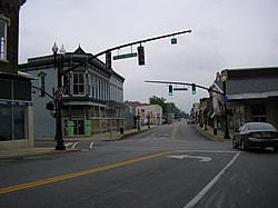
 Downtown Lebanon | |
 Location in Marion County, Kentucky | |
| Coordinates: 37°34′14″N 85°15′23″W / 37.57056°N 85.25639°W | |
| Country | United States |
| State | Kentucky |
| County | Marion |
| Named for | The biblical land famed for its cedars |
| Area | |
| • Total | 6.41 sq mi (16.59 km2) |
| • Land | 6.37 sq mi (16.50 km2) |
| • Water | 0.04 sq mi (0.09 km2) |
| Elevation | 791 ft (241 m) |
| Population | |
| • Total | 6,274 |
| • Estimate (2022)[3] | 6,436 |
| • Density | 984.93/sq mi (380.28/km2) |
| Time zone | UTC-5 (Eastern (EST)) |
| • Summer (DST) | UTC-4 (EDT) |
| ZIP code | 40033 |
| Area code(s) | 270 & 364 |
| FIPS code | 21-44344 |
| GNIS feature ID | 0496130 |
| Website | lebanon |
Lebanon is a home rule-class city[4] and the county seat[5] of Marion County, Kentucky, in the United States. The population was 6,274 at the 2020 census,[2] up from 5,539 in 2010. Lebanon is located in central Kentucky, 63 miles (101 km) southeast of Louisville. A national cemetery is nearby.
- ^ "2022 U.S. Gazetteer Files: Kentucky". United States Census Bureau. Retrieved May 3, 2023.
- ^ a b "P1. Race – Lebanon city, Kentucky: 2020 DEC Redistricting Data (PL 94-171)". U.S. Census Bureau. Retrieved May 3, 2023.
- ^ "Annual Estimates of the Resident Population for Incorporated Places in Kentucky: April 1, 2020 to July 1, 2022". United States Census Bureau. Retrieved May 26, 2023.
- ^ "Summary and Reference Guide to House Bill 331 City Classification Reform" (PDF). Kentucky League of Cities. Retrieved December 30, 2014.
- ^ "Find a County". National Association of Counties. Retrieved June 7, 2011.