Back مقاطعة لبنان (بنسيلفانيا) Arabic Lebanon County, Pennsylvania BAR Лебанон (окръг, Пенсилвания) Bulgarian লেবানন কাউন্টি, পেনসিলভানিয়া BPY Lebanon Gông (Pennsylvania) CDO Лебанон (гуо, Пенсильвани) CE Lebanon County CEB Lebanon County, Pennsylvania Welsh Lebanon County German Kantono Lebanon Esperanto
Lebanon County | |
|---|---|
 | |
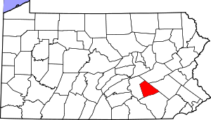
 Location within the U.S. state of Pennsylvania | |
 Pennsylvania's location within the U.S. | |
| Coordinates: 40°22′N 76°28′W / 40.37°N 76.46°W | |
| Country | |
| State | |
| Founded | February 16, 1813 |
| Seat | Lebanon |
| Largest city | Lebanon |
| Area | |
| • Total | 362 sq mi (940 km2) |
| • Land | 362 sq mi (940 km2) |
| • Water | 0.7 sq mi (2 km2) 0.2% |
| Population | |
| • Estimate (2020) | 143,257 |
| • Density | 390/sq mi (150/km2) |
| Time zone | UTC−5 (Eastern) |
| • Summer (DST) | UTC−4 (EDT) |
| Congressional district | 9th |
| Website | www |
Lebanon County (/ˈlɛbnən/ Pennsylvania Dutch: Lebanon Kaundi) is a county in the Commonwealth of Pennsylvania, United States. As of the 2020 census, the population was 143,257.[1] Its county seat is the city of Lebanon.[2] It lies 72 miles northwest of Philadelphia, which is the nearest major city. The county is part of the South Central Pennsylvania region of the state.[a]
The county was formed from portions of Dauphin and Lancaster counties in 1813, with minor boundary revisions in 1814 and 1821.[3] Lebanon County comprises the Lebanon metropolitan statistical area, which is part of the Harrisburg–York–Lebanon combined statistical area.
- ^ "State & County QuickFacts". United States Census Bureau. Archived from the original on June 6, 2011. Retrieved November 17, 2013.
- ^ "Find a County". National Association of Counties. Archived from the original on May 31, 2011. Retrieved June 7, 2011.
- ^ Our County Archived July 9, 2013, at the Wayback Machine. Lebanon County Historical Society. Retrieved on July 23, 2013.
Cite error: There are <ref group=lower-alpha> tags or {{efn}} templates on this page, but the references will not show without a {{reflist|group=lower-alpha}} template or {{notelist}} template (see the help page).
