Lesjaverk | |
|---|---|
Village | |
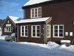
 View of the village railway station | |
| Coordinates: 62°11′32″N 8°32′26″E / 62.19229°N 8.54062°E | |
| Country | Norway |
| Region | Eastern Norway |
| County | Innlandet |
| District | Gudbrandsdalen |
| Municipality | Lesja Municipality |
| Elevation | 634 m (2,080 ft) |
| Time zone | UTC+01:00 (CET) |
| • Summer (DST) | UTC+02:00 (CEST) |
| Post Code | 2667 Lesjaverk |
Lesjaverk is a village in Lesja Municipality in Innlandet county, Norway. It lies in the upper Gudbrandsdal valley approximately 35 kilometres (22 mi) northwest of Dombås and about 11 kilometres (6.8 mi) east of the village of Lesjaskog. The village lies along the European route E136 highway and the Raumabanen railway line. The E136 highway goes from Ålesund up through the Romsdalen valley and passes through Lesjaverk on the way to its end point at Dombås.[2] Located in a high mountain pass at 633 metres (2,077 ft) in elevation, the village is situated between several mountains including the 1,883-metre (6,178 ft) tall Svarthøi, the 1,868-metre (6,129 ft) tall Storhøi, and the 1,702-metre (5,584 ft) tall Merratind which all are part of the Dovrefjell range to the north. The 1,780-metre (5,840 ft) tall mountain Digervarden lies to the south on the other side of the valley.[3][4]
- ^ "Lesjaverk, Lesja". yr.no. Retrieved 11 April 2022.
- ^ Welle-Strand, Erling (1996). Adventure Roads in Norway. Nortrabooks. ISBN 82-90103-71-9.
- ^ "Map of Dovrefjell-Sunndalsfjella National Park". dir.no. Retrieved 24 July 2009.[permanent dead link]
- ^ "The old ironworks /". lesjaverk.no. Retrieved 24 July 2009.


