Back Liao Afrikaans نهر لياو Arabic نهر لياو ARZ Ríu Liao AST لیائو چایی AZB Ляохэ Bashkir Ляахэ Byelorussian Ляохъ Bulgarian লিয়াও নদী Bengali/Bangla Liao Breton
This article needs additional citations for verification. (February 2013) |
| Liao River Liao He | |
|---|---|
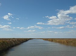
 The Liao River at Panjin, Liaoning | |
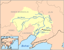
 Map of the Liao River drainage basin | |
| Native name | 辽河 |
| Location | |
| Country | China |
| Province | Hebei, Inner Mongolia, Jilin, Liaoning |
| Physical characteristics | |
| Source | various sources of its tributaries |
| Mouth | Liaodong Bay |
| Length | 1,345 km (836 mi) |
| Basin size | 232,000 km2 (90,000 sq mi) |
 | |
The Liao River (simplified Chinese: 辽河; traditional Chinese: 遼河; pinyin: Liáo Hé) is the principal river in southern Northeast China, and one of the seven main river systems in China. Its name is derived from the Liao region, a historical name for southern Manchuria, from which the Liaoning province, Liaodong Peninsula, and Liao dynasty also derive their names.[1] The river is also popularly known as the "mother river" in Northeast China.[2] Coursing 1,345 kilometres (836 mi) long, the Liao River system drains a catchment basin of over 232,000 square kilometres (90,000 sq mi), but its mean discharge is quite small at only about 500 cubic metres per second (18,000 cu ft/s), about one-twentieth that of the Pearl River. The Liao River has an exceedingly high sediment load because many parts of it flow through powdery loess.
The Liao River is also an important geographical landmark, as it divides the modern Liaoning province into two broad regions — Liaodong ("east of Liao") and Liaoxi ("west of Liao"). Historically, this demarcation though was not based on the river itself, but on a large wetland that once existed on the right (west) bank of the lower Liao River known as the Liao Mire (辽泽), which stretched east of the Yiwulü Mountain to the Liao River from Xinmin to Panshan.
- ^ "Liao River". Encyclopædia Britannica. Retrieved 1 January 2013.
- ^ Cao, Jie. "Liao River in Deep Trouble" (PDF). Archived from the original (PDF) on 2 September 2009. Retrieved 1 January 2013.