Back Лір (Бельгія) Byelorussian Лийр Bulgarian Lier (Belgia) Breton Lier Catalan Lier (parokya) CEB Lier (Belgien) Danish Lier (Belgien) German Λιρ (πόλη) Greek Lier Esperanto Lier (Bélgica) Spanish
Lier | |
|---|---|
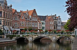
 Hoogbrug over the Nete in Lier | |
| Coordinates: 51°8′N 4°34′E / 51.133°N 4.567°E | |
| Country | |
| Community | Flemish Community |
| Region | Flemish Region |
| Province | Antwerp |
| Arrondissement | Mechelen |
| Government | |
| • Mayor | Rik Verwaest (N-VA) |
| • Governing party/ies | N-VA, Open Vld |
| Area | |
• Total | 49.85 km2 (19.25 sq mi) |
| Population (2020-01-01)[1] | |
• Total | 36,646 |
| • Density | 740/km2 (1,900/sq mi) |
| Postal codes | 2500 |
| NIS code | 12021 |
| Area codes | 03, 015 |
| Website | www.lier.be |
Lier (Dutch: [liːr] ; French: Lierre [ljɛʁ] ) is a municipality located in the Belgian province of Antwerp. It is composed of the city of Lier proper and the village of Koningshooikt. The city centre is surrounded by the river Nete, around which it grew. In 2018, Lier had a total population of 35,712. The total area is 49.70 km2 making a population density (PD) of 720 per km2. Lier is known for its beers (which include Caves), its patron saint St. Gummarus and Lierse vlaaikes cake. It is also home to the world headquarters of Van Hool, a global bus and coach manufacturer. Lier's two principal football clubs are K. Lyra-Lierse and Lierse Kempenzonen (formerly known as KFC Oosterzonen, which moved to Lier in 2018).
- ^ "Bevolking per gemeente op 1 januari 2020". Statbel.


