Back Lingewaard Afrikaans لينجافارد Arabic Lingewaard Catalan Gemeente Lingewaard CEB Lingewaard German Lingewaard Esperanto Lingewaard Spanish Lingewaard Basque لینگهوارد Persian Lingewaard French
Lingewaard | |
|---|---|
 | |
 Location in Gelderland | |
| Coordinates: 51°53′N 5°54′E / 51.883°N 5.900°E | |
| Country | Netherlands |
| Province | Gelderland |
| Government | |
| • Body | Municipal Council |
| • Mayor | Josan Meijers (PvdA) |
| Area | |
| • Total | 69.14 km2 (26.70 sq mi) |
| • Land | 62.00 km2 (23.94 sq mi) |
| • Water | 7.14 km2 (2.76 sq mi) |
| Elevation | 11 m (36 ft) |
| Population (2020)[4] | |
| • Total | 46,625 |
| • Density | 755/km2 (1,960/sq mi) |
| Demonym | Lingewaarder |
| Time zone | UTC+1 (CET) |
| • Summer (DST) | UTC+2 (CEST) |
| Postcode | 6680–6681, 6684–6691, 6850–6852 |
| Area code | 026, 0481 |
| Website | Lingewaard.nl |

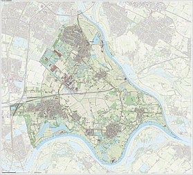
Lingewaard (Dutch pronunciation: [ˌlɪŋəˈʋaːrt] ) is a municipality in the eastern Netherlands. It is located in the province of Gelderland, in the most eastern part of the Betuwe. The municipality is situated in the lowlands between the major cities of Arnhem and Nijmegen, where many inhabitants work. Since 2021 it has been part of the Arnhem-Nijmegen Green Metropolitan Region (Dutch: Groene Metropoolregio Arnhem-Nijmegen), which aids planning and development in the region's eighteen municipalities.[5]
- ^ "Samenstelling College van B&W" [Members of the Board of Mayor and Aldermen] (in Dutch). Gemeente Lingewaard. Archived from the original on 14 July 2014. Retrieved 8 July 2014.
- ^ "Kerncijfers wijken en buurten 2020" [Key figures for neighbourhoods 2020]. StatLine (in Dutch). CBS. 24 July 2020. Retrieved 19 September 2020.
- ^ "Postcodetool for 6681BJ". Actueel Hoogtebestand Nederland (in Dutch). Het Waterschapshuis. Archived from the original on 21 September 2013. Retrieved 8 July 2014.
- ^ "Feiten en cijfers" [Population numbers of the municipality]. 1 January 2020.
- ^ "Website Groene Metropoolregio Arnhem-Nijmegen" (in Dutch). Retrieved 8 January 2023.
