Back لينوود Arabic لينوود (ليفينوورث, كانزاس) ARZ Linwood (Kansas) Catalan Линвуд (Канзас) CE Linwood (lungsod sa Tinipong Bansa, Kansas) CEB Linwood (Kansas) Spanish Linwood (Kansas) Basque لینوود، کانزاس Persian Linwood (Kansas) French Linwood, Kansas HT
Linwood, Kansas | |
|---|---|
 Aerial view of Linwood (2017) | |
 Location within Leavenworth County and Kansas | |
 | |
| Coordinates: 39°00′07″N 95°02′11″W / 39.00194°N 95.03639°W[1] | |
| Country | United States |
| State | Kansas |
| County | Leavenworth |
| Founded | 1860s |
| Platted | 1867 |
| Incorporated | 1895 [2] |
| Named for | Linden tree |
| Area | |
| • Total | 0.60 sq mi (1.56 km2) |
| • Land | 0.58 sq mi (1.51 km2) |
| • Water | 0.02 sq mi (0.05 km2) |
| Elevation | 804 ft (245 m) |
| Population | |
| • Total | 415 |
| • Density | 690/sq mi (270/km2) |
| Time zone | UTC-6 (CST) |
| • Summer (DST) | UTC-5 (CDT) |
| ZIP code | 66052 |
| Area code | 913 |
| GNIS ID | 2395727[1] |
| Website | cityoflinwood.org |
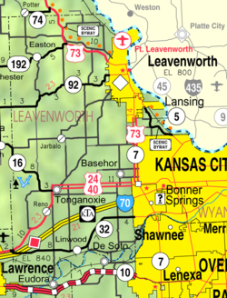
Linwood is a city in Leavenworth County, Kansas, United States,[1] and part of the Kansas City metropolitan area.[5] As of the 2020 census, the population of the city was 415.[4] It is located along K-32 highway between Lawrence and Bonner Springs.
- ^ a b c d U.S. Geological Survey Geographic Names Information System: Linwood, Kansas
- ^ a b "City of Linwood". The League of Kansas Municipalities. May 29, 2019.
- ^ "2019 U.S. Gazetteer Files". United States Census Bureau. Retrieved July 24, 2020.
- ^ a b "Profile of Linwood, Kansas in 2020". United States Census Bureau. Archived from the original on November 19, 2022. Retrieved November 19, 2022.
- ^ "Population Data and Maps | MARC". Archived from the original on September 16, 2014. Retrieved October 14, 2019.